#
📌┆mapping-advice
Page 1 of 1


Davidmin
This channel is gonna be merged with # 📚┆resources.

Starboard 1 APP
03/23/2025 at 6:47 AM GMT+5:30📌 1 | # 🗾┆real-mapping

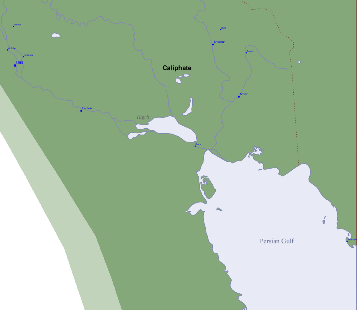
the same author made some other decent maps too http://gallica.bnf.fr/services/engine/search/sru?operation=searchRetrieve&version=1.2&startRecord=0&maximumRecords=50&page=1&query=%28%28dc.creator%20all%20%22Longnon%2C%20Auguste%22%20or%20dc.contributor%20all%20%22Longnon%2C%20Auguste%22%29%29&filter=dc.type%20all%20%22carte%22
Starboard 1 APP
03/15/2025 at 1:28 AM GMT+5:30📌 5 | # Channel Not Found

This was a nightmare, when I did some mistakes on the frame on the start, and I had to change almost all of the frames to erase the places of mistake . Open 7 files, copy, paste, paste, paste, save all, close. That is time consuming. But my motivation is "there will be a project , topic of which is NOT observed or remembered. You should close this gap!" So that is why I waste months on a single project if it is original or big. I am trying to be careful and trying to not do mistakes that I will regret later , lol
Starboard 1 APP
02/02/2025 at 9:51 AM GMT+5:30📌 2 | # Channel Not Found

its weird that genoa specifically dominated

it got an imperial diploma in 958 that separated it from the marches entirely - extremely early independence grant basically which allowed it a very early start on things like diplomacy and overseas activity, putting it into a similar position as venice and pisa savona wasn't too far off - de facto independent since 1059 - but it just didn't have as much prestige/influence, its independence only being fully recognized until 1191 it didn't stop it from getting quite close to genoa in strength at times though; before its first loss against genoa in 1227 that would send it tumbling down into more and more, it was getting closer to being on equal footing, even participating with genoa on some ventures like crusades and cyprus other ligurian republics like albenga and ventimiglia also thrived in this time, but genoa was just too strong, and though the rest all put their faith in the emperor against the sole guelph (papal-aligned) state of genoa (technically noli too but it was tiny and irrelevant and just became genoa's lapdog to keep its independence until napoleon), savona and co. just weren't able to stop the constant relentless assault of genoa; it did take until 1528 for savona's final subjugation though
Starboard 1 APP
01/19/2025 at 5:23 AM GMT+5:30📌 2 | # 🗾┆real-mapping
series of books with documents and treaties about the history of the Duchy of Luxembourg during the middle ages https://luxemburgensia.bnl.lu/cgi/luxonline1_2.pl?action=co&sid=urku_quell
Starboard 1 APP
12/03/2024 at 2:56 AM GMT+5:30📌 4 | # 🗾┆real-mapping

also made this today https://www.youtube.com/playlist?list=PLkrAmUYt2HcOxsfEu1Pe4jZhpLEIuQeKH


Starboard 1 APP
11/27/2024 at 2:45 AM GMT+5:30📌 3 | # 🗾┆real-mapping

Did you guys know I have a folder with all research documents for my videos? https://drive.google.com/drive/u/0/folders/1msQSPlK746jxpP5AZqkrJBnQyo9PqYoA
Starboard 1 APP
11/03/2024 at 5:51 AM GMT+5:30📌 3 | # 🗾┆real-mapping

Starboard 1 APP
11/03/2024 at 5:41 AM GMT+5:30📌 3 | # 🗾┆real-mapping

whats ur process

In Google books when you get a preview, you can paste the last part of it in quotations "like this" and the preview it gives you with that is the part starting with that
Starboard 1 APP
10/30/2024 at 4:44 AM GMT+5:30📌 2 | # 🗾┆real-mapping

@Ollie Bye for you HRE video, will you show all the wars between the principalities?

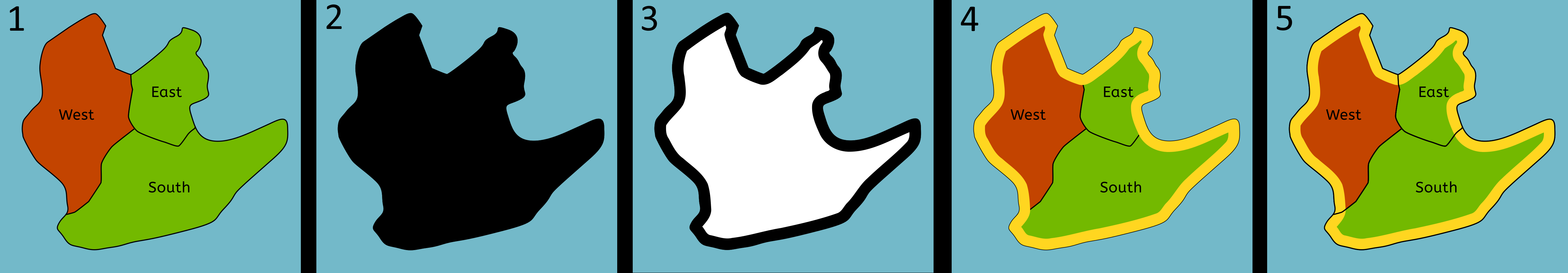
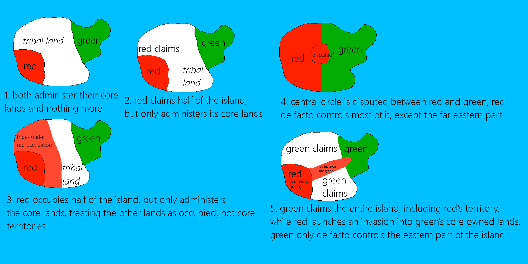
Well, sort of. One thing mappers often do (a mistake in my option) is to distinguish between occupied areas and regular control. In medieval Germany at least, if you conquered the main castle of a lordship for example, you are for all intents and purposes the new lord of that castle. To show it as occupied is just a meaningless detail. On top of this, There weren't frontlines/trenches at this time, so pinning down an occupied area is very difficult (it's arguably also meaningless). So for the medieval period, I won't actually be showing areas as occupied; if an area changes hands due to a military conflict, I will simply make it part of the state that's conquered it. These parameters are different for the early modern period, so I will make a distinction for occupied areas from the Italian Wars onwards. @fabulous Dodolulupepe Ji 姬 has argued I push this back slightly to the wars in Lombardy, but yeah it'll be around the 1400s when I start doing that in any case.
Starboard 1 APP
10/29/2024 at 4:41 AM GMT+5:30📌 4 | # 🗾┆real-mapping

I'll probably need some tutorials to learn how to use it (again)
Starboard 1 APP
10/22/2024 at 4:58 PM GMT+5:30📌 3 | # 🗾┆real-mapping

Starboard 1 APP
10/21/2024 at 6:56 AM GMT+5:30📌 2 | # 🌍┆general-chat

use sites like https://www.landkartenarchiv.de/ https://gallica.bnf.fr/html/und/cartes/cartes https://www.oldmapsonline.org/en https://uwm.edu/lib-collections/agsl-digital-map-collection/ https://www.davidrumsey.com/ https://catalog.archives.gov/id/305945 to find maps
Starboard 1 APP
09/21/2024 at 3:27 AM GMT+5:30📌 6 | # Channel Not Found

Starboard 1 APP
09/20/2024 at 11:59 PM GMT+5:30📌 4 | # 🗾┆real-mapping

ok mr. "ussr ukrughs"

the day i come here and show something that resembles the outline of the kineshma okrug is the day yall can send me to the psych ward
Starboard 1 APP
09/16/2024 at 8:10 AM GMT+5:30📌 3 | # 😂┆off-topic

idk what any of it means but at least I now know what to look for


Starboard 1 APP
09/16/2024 at 8:04 AM GMT+5:30📌 3 | # 😂┆off-topic
how do I get it not to lag so hard when I make a cut in the footage
Generate proxy media, set timeline proxy resolution to Quarter, and Render Cache to Smart
Starboard 1 APP
09/11/2024 at 2:28 AM GMT+5:30📌 3 | # 🗾┆real-mapping
📌 1 | # 🗾┆real-mapping

Starboard 1 APP
08/19/2024 at 5:52 AM GMT+5:30📌 10 | # 🗾┆real-mapping

Starboard 1 APP
07/05/2024 at 4:19 PM GMT+5:30📌 3 | # 📰┆news-chat

Starboard 1 APP
06/20/2024 at 4:37 AM GMT+5:30📌 3 | # 🗾┆real-mapping

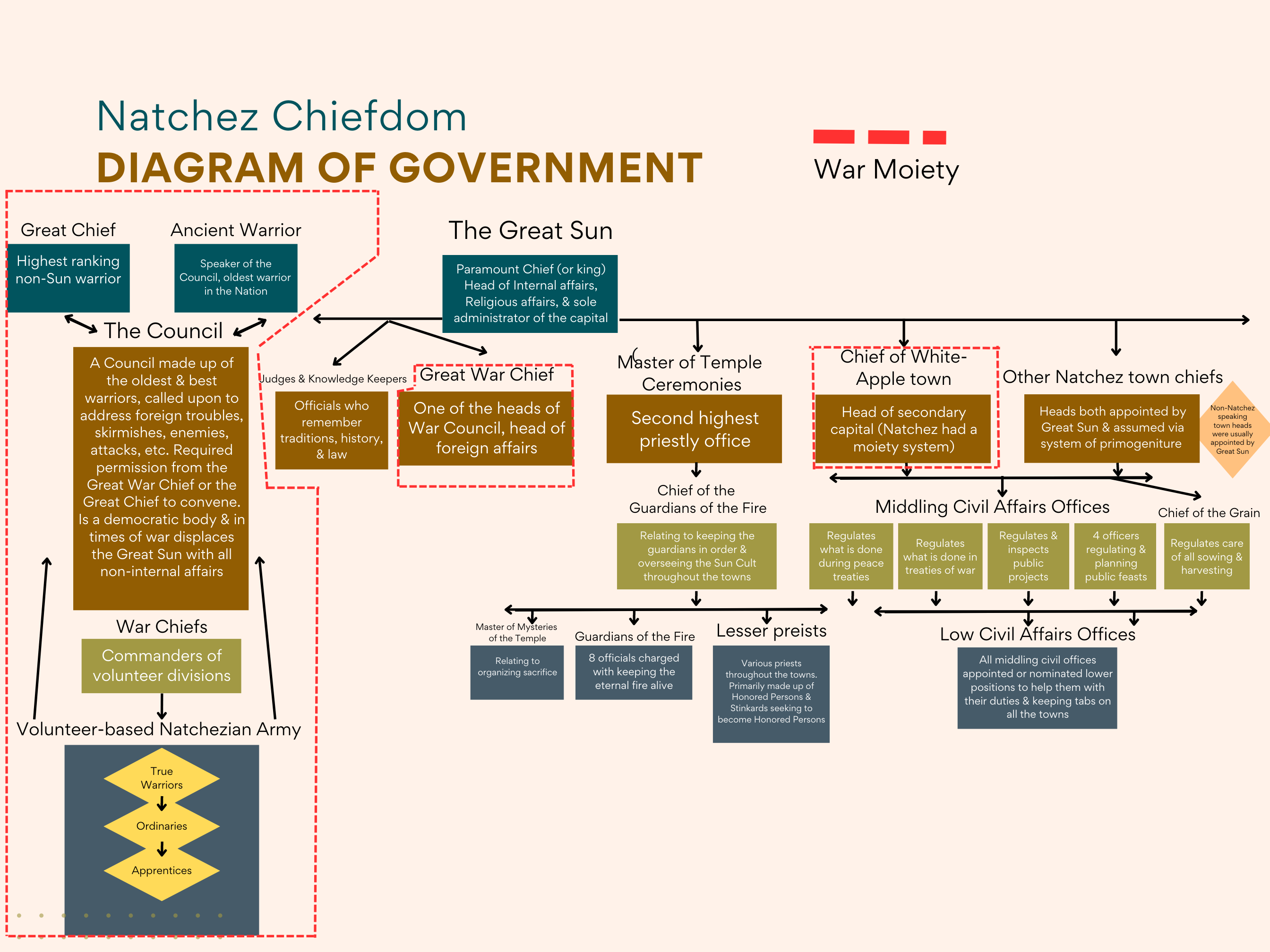
 - Handbook of North American Indians...._.a93231b9-19df-4a2a-8f9f-2aa6853607fe.png)
Starboard 1 APP
04/28/2024 at 12:14 AM GMT+5:30📌 1 | # 🗾┆real-mapping


Starboard 1 APP
04/19/2024 at 2:46 AM GMT+5:30📌 3 | # 🗾┆real-mapping
is there any good source on polish borders also?

Starboard 1 APP
03/28/2024 at 11:38 PM GMT+5:30📌 1 | # 💡┆suggestions

alright, thank you!

Here. It's png so some parts are too dark to read... but is in a good resolution, you just have to zoom in.
Starboard 1 APP
03/11/2024 at 5:45 AM GMT+5:30📌 3 | # 🗾┆real-mapping

then just line it up (use the sides because corner is confusing (this only works if the format is equirectangular)
📌 1 | # 🗾┆real-mapping
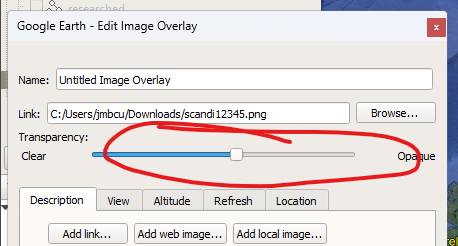
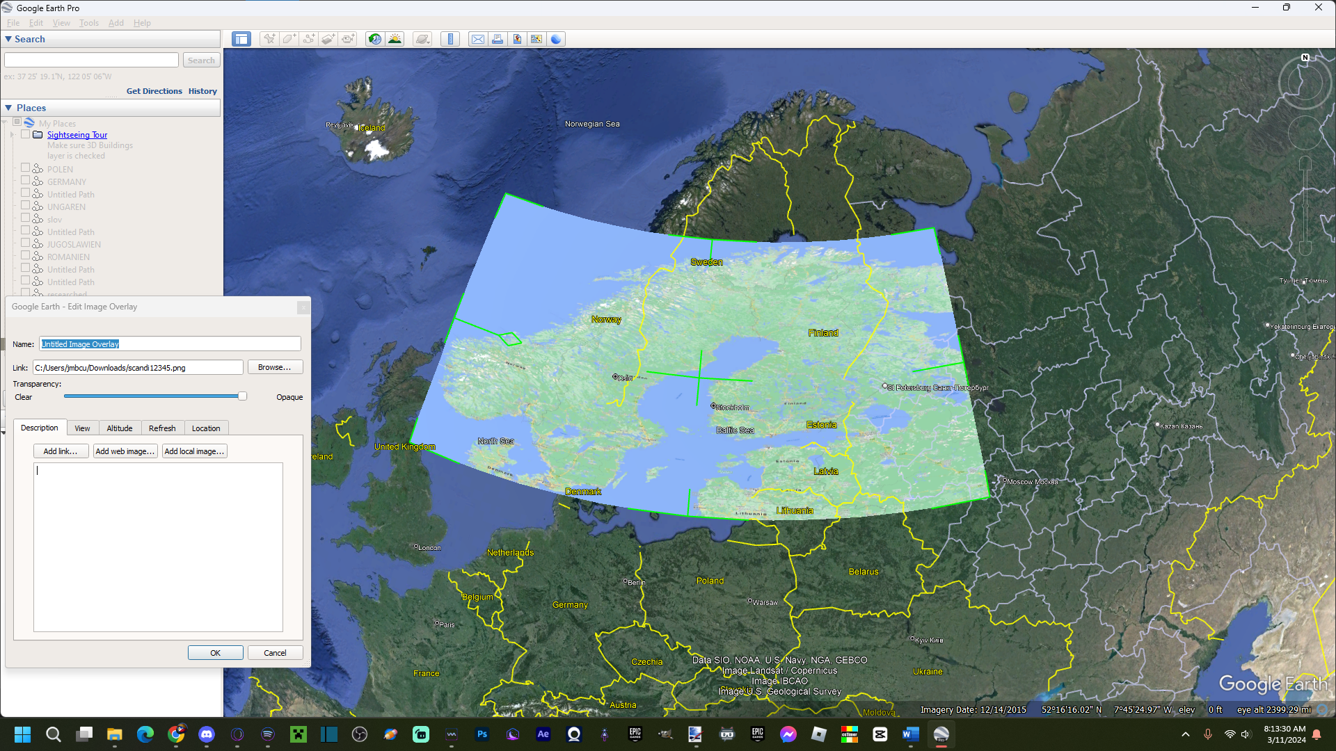
📌 1 | # 🗾┆real-mapping
HOW TO TURN FLAT MAP TO CURVED MAP click on the image overlay at the top
Starboard 1 APP
03/08/2024 at 11:08 PM GMT+5:30📌 1 | # 🗾┆real-mapping

@User Not Found https://archive.org/search?query=Robert+Hewsen
Starboard 1 APP
03/04/2024 at 1:55 AM GMT+5:30📌 1 | # 🌍┆general-chat

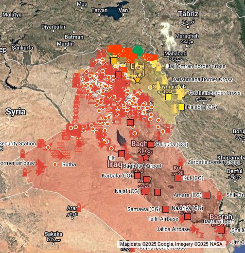
There's online map of iraq PKK insurgency https://www.google.com/maps/d/viewer?mid=1EXnjz0SpWMkoWtYnE_8h3BGmAiITbuLy&ll=34.45306777821909%2C43.33289396138558&z=7
Syria-Irak: https://www.google.com/maps/d/viewer?mid=1liqnO9iSvshTLwgPB3q9sJTgfUI&ll=34.698059967918276%2C36.800262605602825&z=6 Libya-Yemen: https://www.google.com/maps/d/u/0/viewer?hl=es&mid=1GP3bn4xtm3p2QkVCb83QU_s5LjU&ll=15.637009817224122%2C45.614475223883346&z=5 La verdad es la verdad, no lo que diga la mayoria, este mapa expone la gue...
Starboard 1 APP
03/03/2024 at 9:20 PM GMT+5:30📌 10 | # 🗾┆real-mapping
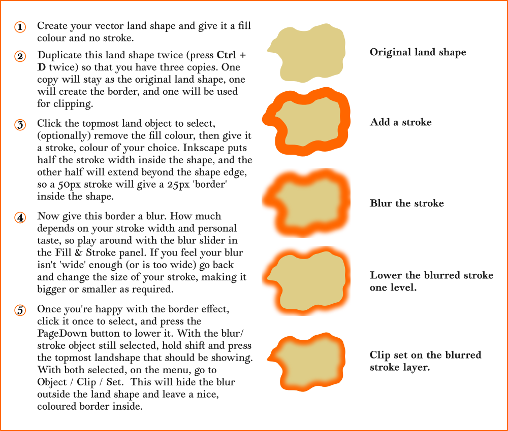
It's kind of complicated, but it should make sense when you do it. 1) Draw the shape or shapes you want to have an outline around, and add any text you want. Make sure the shapes have a thin black outline as well. 2) Duplicate all the shapes, and merge them into one object. I set its Fill to black in the images below, but you don't have to). 3) Navigate to the _Paint Bucket Tool_, set its Growth/Shrink by to a negative value, and click on the shape. This may take a couple of attempts to get the right size; if you want to retry, delete the shape it creates first. I set the Fill to white in the images below, but again this isn't necessary. 4) Select the two objects we generated in steps 2 and 3, navigate to Path > Difference. This will cut the smaller shape out of the bigger one, leaving you with an outline. You can colour the outline's Fill as you wish, but make sure it's Stroke is set to 0 opacity. 5) As it stands, the thick outline is covering up the black outlines of the objects. To fix this, duplicate the original shapes again, set their Fill to 0 opacity, and make sure they're ordered above the thick outline.
Starboard 1 APP
02/28/2024 at 3:33 PM GMT+5:30📌 2 | # 🗾┆real-mapping

How to create a map:- > - Download paint.net or any other software, if you're a beginner, I'd suggest you to use paint.net > > -Trace a base map (Also re-check whether you traced each and every pixel > > -Research (The most important component in creating a map) > > -Do not proceed making another slide of your map if it isn't satisfactorily accurate > > -Try to improve the accuracy of your map > > -Post it in discord/reddit ; tolerate & consider constructive criticism > > -Refrain from making errors/distorting historical events on-purpose > > -Get started, what're you waiting for?
Starboard 1 APP
02/18/2024 at 4:05 AM GMT+5:30📌 9 | # 🗾┆real-mapping


Starboard 1 APP
02/17/2024 at 1:13 AM GMT+5:30📌 1 | # 🗾┆real-mapping

For those who are searching for a specific location in Brazil and can't find it on Google Maps. Try using the municipal maps of the Brazilian Institute of Geography and Statistics, they are a good way of finding small towns that don't appear on other maps. Another good tool is the Brazilian Army's Geographic Database, which has very precise topographic maps that are a little old, but you may find a location there. BDGEx - https://bdgex.eb.mil.br/bdgexapp/mobile IBGE - https://cidades.ibge.gov.br
Starboard 1 APP
02/10/2024 at 9:30 PM GMT+5:30📌 1 | # 🗾┆real-mapping

Here it is. Many hours of research and still not correct in some parts
Starboard 1 APP
02/01/2024 at 9:30 PM GMT+5:30📌 1 | # 🗾┆real-mapping
Tip for MyMaps. Use the old icons to represent capitals, cities, towns or other locations, because they don't overlay icons for events or battles.
Starboard 1 APP
01/30/2024 at 1:30 PM GMT+5:30📌 2 | # 🗾┆real-mapping

Im gonna make a little video on that

https://scholar.archive.org/work/g5556gof2rarvg35pjy47sc75y
Starboard 1 APP
01/27/2024 at 11:20 PM GMT+5:30📌 3 | # 🗾┆real-mapping

can you show me

Starboard 1 APP
01/13/2024 at 5:19 AM GMT+5:30📌 1 | # 🗾┆real-mapping

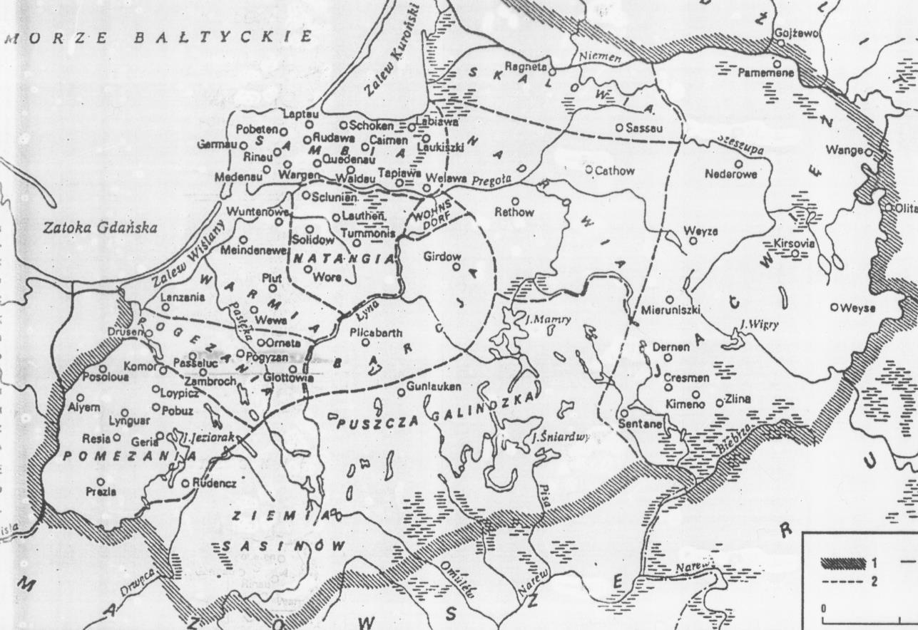
@User Not Found im going to guess that Lamata, which are believed to be Skalvians, were a pulka, fairly large in area but bit sparely populated bit, mentioned as lamata guys by teutons
📌 3 | # 🗾┆real-mapping

was it mentioned as a "Terra" or "Territory" or "Terrula" or "Pulka" or "Pulca" or "Polka"
Starboard 1 APP
01/13/2024 at 12:08 AM GMT+5:30📌 1 | # 🗾┆real-mapping
@User Not Found here is one of the maps, all of the dots count as pulkas

fabulous Dodolulupepe Ji 姬
the new layer is unnecessary, you can just do effects>stylize>outline directly on the magic selected area in the original layer
Starboard 1 APP
12/20/2023 at 2:53 AM GMT+5:30📌 1 | # 🗾┆real-mapping

How I do outlines in Paint.NET: 1. Select the regions you wanna make an outline for using the magic wand (use shift+click with the magic wand to select all regions of the same color) 2. Make a new layer, and fill the selection with a random color in that new layer 3. While keeping the selection active, go to Effects > Stylize > Outline 4. Set the Intensity to the maximum (100) and use the Thickness slider to adjust the width of the outline. Hit OK 5. Delete the unnecessary filling (in white), and recolor and merge the layers according to your wishes
Starboard 1 APP
12/06/2023 at 8:20 AM GMT+5:30📌 1 | # 🗾┆real-mapping
Website to turn Coordinates from Degrees-Minutes-Seconds to Decimals https://planetcalc.com/1129/ Useful for georeferencing
Starboard 1 APP
11/28/2023 at 9:20 AM GMT+5:30📌 2 | # 🗾┆real-mapping

also to prevent the hillshade texture from being too grainy you have to change the Resampling to Cubic

Starboard 1 APP
09/11/2023 at 6:08 AM GMT+5:30📌 7 | # 🗾┆real-mapping

the map ive been procrastinating doing for like a month and some more is finally done, if any of you notice any mistakes let me know, ill fix them tomorrow and then upload it, but until then its technically not done, but yea ill post it into resources and online tomorrow
Starboard 1 APP
06/08/2023 at 9:18 AM GMT+5:30⭐ 5 | # 🗾┆real-mapping

send them :Steamhappy:

https://sejarah-nusantara.anri.go.id/daily_journals_volumes/
Starboard 1 APP
04/03/2023 at 9:25 PM GMT+5:30📌 1 | # 🗾┆real-mapping

Starboard 1 APP
04/03/2023 at 9:25 AM GMT+5:30📌 4 | # 🌍┆general-chat

Starboard 1 APP
04/02/2023 at 2:22 AM GMT+5:30⭐ 2 | # 🗾┆real-mapping

update
dunno if this applies to your map, but from what I read the Caucasus Huns inhabited areas from the Sulak river basin to the Derbent gates
Starboard 1 APP
03/20/2023 at 4:36 AM GMT+5:30⭐ 2 | # 🗾┆real-mapping

@User Not Found CAN I USE YOUR COLORS FOR CELTS LOLLL

https://cdn.discordapp.com/attachments/758151324067561474/1086672225983275089/image.png
Starboard 1 APP
03/07/2023 at 11:33 PM GMT+5:30⭐ 3 | # 🗾┆real-mapping

This is a very useful tool for translating some French texts (after all, a lot of historical texts and other important resources are written in French). Here's a summarized version of these tricks: 1. Change the é at the beginning of words to an s (for example épouse -> spouse, éponge -> sponge, étudiant -> stud(e)nt). A few words might be a bit tricky, like état or école, but it's easy to understand with some phonetic gymnastics. 2. When encountering letters with hats (like Ô, Â, Ê), place an s after that letter. For example, forêt -> forest or hôpital -> hospital. 3. Change gu in French words to w in order to convert them to English. For example, Guillaume -> Will(ia)m or guerre -> w(a)r.
Starboard 1 APP
03/07/2023 at 7:36 PM GMT+5:30⭐ 1 | # 👥┆trusted

Starboard 1 APP
03/03/2023 at 3:19 PM GMT+5:30⭐ 1 | # 🗾┆real-mapping
History of the Bieszczady Mountains c. 970: Boleslaus II of Bohemia conquers the Bieszczady Mountains 981: Vladimir the Great of Rus' takes the areas north of the Bieszczadys during one of his conquests 999: Boleslaus II dies and Vladimir takes over the rest of the mountains 1018: During the Kievan succession crisis, Bolesław I of Poland takes over the Bieszczady Mountains following an expedition to Kiev 1031: Yaroslav I reconquers the mountains from Poland 1070: Bolesław II of Poland reconquers the Bieszczadys once again c. 1076: The Rus' retakes the Bieszczadys 1085: Principality of Peremyshl is formed with the Bieszczadys as part of it 1141: The principalities of Peremyshl, Zvenigorod and Terebovlia form the Principality of Halych 1199: The Kingdom of Galicia-Volhynia takes control of the Bieszczady Mountains 1340: The Peremyshl Land is taken over by the Polish 1345: Peremyshl, Sanok etc becomes part of Lithuania 1352: The Principality of Galicia once again conquers the Bieszczadys 1370: The Hungarian king Louis I takes over Galicia 1387: The Bieszczadys are attached to Poland by Queen Jadwiga 1434: Ruthenia Voivodeship is formed with the Bieszczadys part of it 1569: The Polish-Lithuanian Commonwealth is formed 1772: The Bieszczadys, following the First Partition of Poland, are incorporated into the Kingdom of Galicia and Lodomeria 1914: A Russian occupation force retreats back to their homeland following the Battle of Limanowa 1918: The Western Ukrainian People's Republic (WUPR) takes control of the Bieszczadys from Austria-Hungary 1918: The Lemko Republic takes control of Sanok 1919: The WUPR and Lemko Republic fall to Poland 1921: Poland's borders, including the claim on the Bieszczadys, are recognized internationally 1939: The Bieszczadys are divided between the German Reich and Soviet Union following their invasion of Poland 1945: Poland's new borders in the Bieszczadys are the same as those proclaimed following the invasion
Starboard 1 APP
02/28/2023 at 10:38 PM GMT+5:30⭐ 1 | # 🗾┆real-mapping

here is the only one source i have, it shows invasion of kiev, but there are more of these for sure
Starboard 1 APP
02/28/2023 at 10:19 PM GMT+5:30⭐ 1 | # 🗾┆real-mapping
Events of the Polish intervention in the Kievan war of succession (1018) June: Bolesław prepares his troops July 1-22: Bolesław leads his troops to the Southern Bug and also conquers Volhynia while Pechengs approach Kiev from the south July 23: Battle of the River Bug occurs somewhere near today's Volodymyr July 23: Pechengs begin their siege of Kiev August 14: Bolesław I's army arrives in Kiev and captures the city Unknown date, circa September 1 ("not long after the fall of Kiev" according to the Primary Chronicle): Bolesław I is forced to flee Kiev
Starboard 1 APP
02/17/2023 at 11:59 PM GMT+5:30📌 1 | # 🗾┆real-mapping

I’m aware I showed a very simplified version of the Sakas and the Odrysians and also where can I find the Soviet texts on them?

To find soviet academic articles on the Scythians, you must do your search in Russian. Meaning you can translate your search from English to Russian and then you copy and paste the Russian in Google Scholar. I have a multitude of translation and document access tools to help you research. Let me list them here: (For accessing books) https://annas-archive.org/ https://libgen.is/search.php (For accessing documents/articles and also getting documents) https://www.sci-hub.st/ https://www.jstor.org/ https://www.academia.si/en/ https://www.researchgate.net/ (Translation) https://translate.yandex.com/ Before you use one of your free 100 articles on JSTOR, make sure if you can access it through sci-hub. Sci-hub finds documents based on their number DOI (Digital Object Identification).
Get the Real Skills for the Real World in Academia's applied short-cycle higher education programmes. Learn about Studying in Slovenia!

Starboard 1 APP
02/17/2023 at 11:52 PM GMT+5:30⭐ 1 | # 🗾┆real-mapping

Btw guys if you're ever mapping Scythians, translate archaeological research documents made by Soviet scholars, I swear this will save you so much time of finding sources in English.
Starboard 1 APP
02/17/2023 at 1:14 AM GMT+5:30⭐ 1 | # Channel Not Found

Starboard 1 APP
01/20/2023 at 6:31 AM GMT+5:30⭐ 8 | # 📚┆resources

Map of Africa by Treaty Volume I All British Colonies, Protectorates and Possessions in Africa https://ia800809.us.archive.org/15/items/mapofafricabytr01hert/mapofafricabytr01hert.pdf 498 pages of absolute gold, volumes II & III available on Internet Archive
Starboard 1 APP
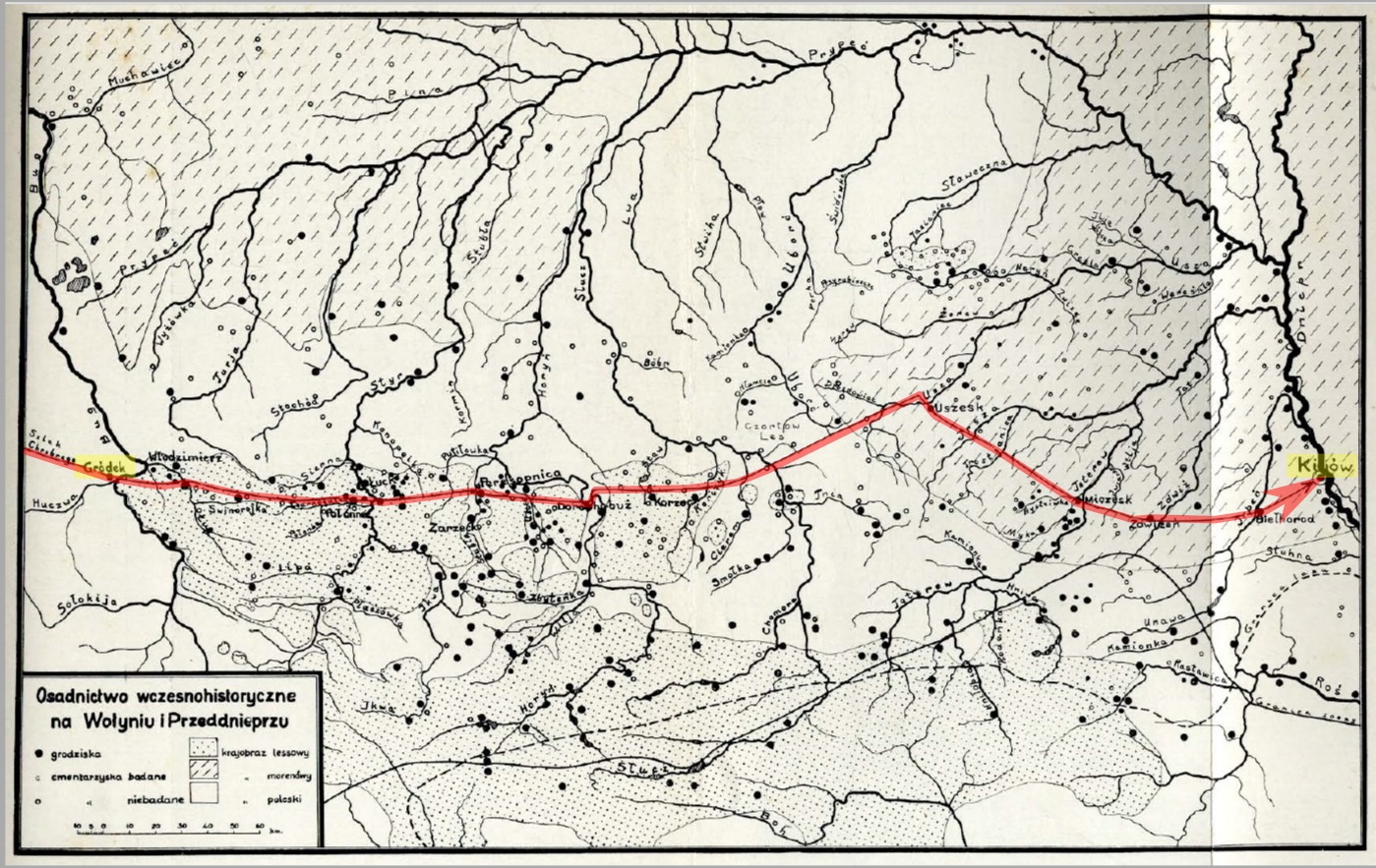
01/14/2023 at 2:39 AM GMT+5:30📌 1 | # 🗾┆real-mapping
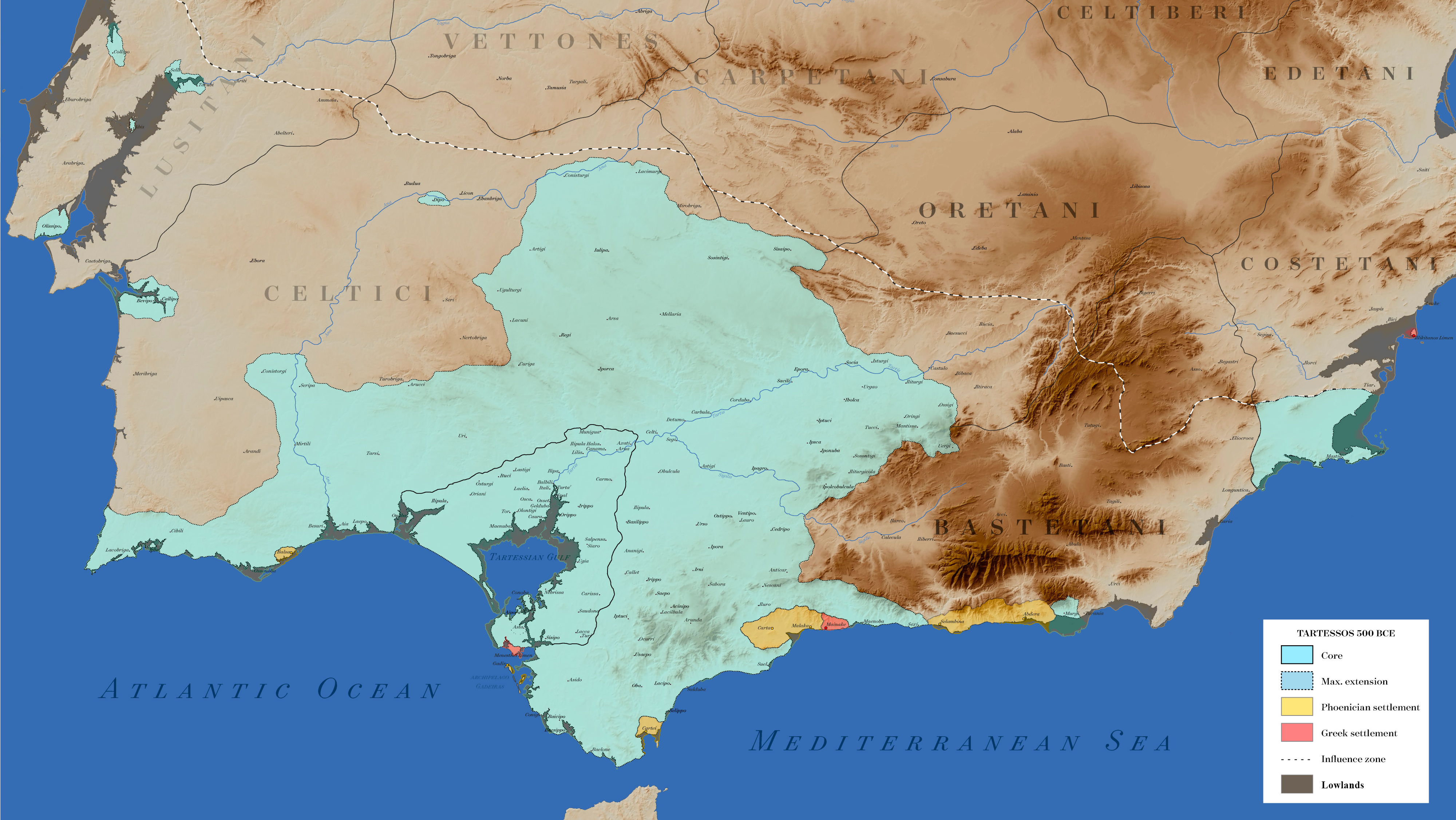
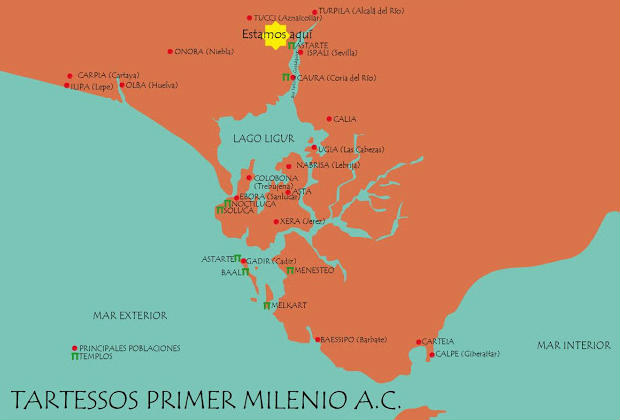
>https://upload.wikimedia.org/wikipedia/commons/8/84/Tartessos_500_BCE.jpg Tartessos in 500 BCE >https://destinoysabor.com/blog/wp-content/uploads/2018/05/105b4968caeb4e4169b34c987ac48b01.jpg Closeup on the Tartessian core circa 1000 BCE Coudln't find any detailed map on Carthage, but this may also be useful https://www.ub.edu/geocrit/aracne/aracne-135.htm
Starboard 1 APP
12/31/2022 at 10:25 PM GMT+5:30⭐ 1 | # 🗾┆real-mapping

Luxtay the Glue Eater
Unfinished Polish highways by date they are promised to be finished: A18 (Olszyna-Krzyżowa): 2023 A2 (Kałuszyn-Biała Podlaska): 2024 A50 (Warsaw bypass): 2027
Starboard 1 APP
12/29/2022 at 4:58 PM GMT+5:30⭐ 1 | # 🗾┆real-mapping
Luxtay the Glue Eater
A4 and A6 sections by date of finished construction A4 (Jędrzychowice-Zgorzelec): 1994 A4 (Kleszczów-Mysłowice): 1996 A4 (Bielany Wrocławskie-Przylesie): 2000 A4 (Przylesie-Nogowczyce): 2003 A4 (Nogowczyce-Kleszczów): 2003 A4 (Kleszczów-Katowice): 2005 A4 (Krzyżowa-Bielany Wrocławskie): 2006 A6 (Szczecin bypass): 2007 A4 (Zgorzelec-Krzyżowa): 2009 A4 (Kraków bypass): 2009 A4 (Kraków-Szarów): 2009 A4 (Rzeszów bypass): 2012 A4 (Szarów-Tarnów): 2013 A4 (Dębica-Rzeszów): 2013 A4 (Jarosław-Korczowa): 2013 A4 (Tarnów-Dębica): 2014 A4 (Rzeszów-Jarosław): 2016 + A8, which is a Wrocław bypass built in 2011
⭐ 1 | # 🗾┆real-mapping
Luxtay the Glue Eater
A1 and A2 sections by date of finished construction A2 (Września-Golina): 1985 A2 (Golina-Modła): 1988 A1 (Tuszyn-Piotrków Trybunalski): 1989 A2 (Poznań-Września): 2003 A2 (Nowy Tomyśl-Poznań): 2004 A2 (Modła-Stryków): 2006 A1 (Gdańsk-Grudziądz): 2008 A2 (Stryków-Łódź): 2008 A1 (Gliwice-Bełk): 2009 A1 (Grudziądz-Toruń): 2011 A1 (Zabrze-Gliwice): 2011 A1 (Bełk-Świerklany): 2011 A2 (Świecko-Nowy Tomyśl): 2011 A1 (Kowal-Łódź): 2012 A1 (Pyrzowice-Zabrze): 2012 A2 (Łódź-Warsaw): 2012 A2 (Choszczówka Stojecka-Kałuszyn): 2012 A1 (Toruń-Kowal): 2014 A1 (Świerklany-Gorzyczki): 2014 A1 (Łódź-Tuszyn): 2016 A1 (Częstochowa bypass): 2019 A1 (Częstochowa-Pyrzowice): 2019 A2 (Warsaw bypass): 2021 A1 (Piotrków Trybunalski-Kamieńsk): 2022
Starboard 1 APP
12/25/2022 at 8:15 PM GMT+5:30⭐ 3 | # 🗾┆real-mapping
Luxtay the Glue Eater
20 largest Polish cities by the date they were given city rights 1214: Wrocław 1233: Toruń 1243: Szczecin 1250: Gliwice 1253: Poznań 1257: Kraków 1263: Gdańsk 1295: Kielce 1323: Warsaw 1317: Lublin 1346: Bydgoszcz 1353: Olsztyn 1354: Rzeszów 1356: Częstochowa 1364: Radom 1423: Łódź 1692: Białystok 1865: Katowice 1902: Sosnowiec 1926: Gdynia
Starboard 1 APP
12/11/2022 at 9:29 PM GMT+5:30⭐ 6 | # 🗾┆real-mapping
Civil War battles in Alabama by date April 23, 1862: Siege of Bridgeport - Northeast Alabama occupied by Union forces April 28, 1862: Skirmish at Paint Rock Bridge - Further Union advances into Northeast Alabama April 30, 1863: Battle of Day's Gap - Successful attack on and Union occupation of Northwest Alabama January 26, 1864: Battle of Athens - Failed attack on a Union outpost in Northern Alabama August 5, 1864: Battle of Mobile Bay - Fall of Mobile Bay to the Union September 25, 1864: Battle of Sulphur Creek Trestle - Athens, Alabama falls to the Confederates October 21, 1864: Battle of Cherokee Station - Successful Union occupation of northwest Alabama October 29, 1864: Battle of Decatur - Successful Union defence of Northern Alabama March 14, 1865: Battle of Newton - Confederate forces force Union forces out of southwest Alabama April 1, 1865: Battle of Ebenezer Church - Significant Union advances into Central Alabama April 2, 1865: Battle of Selma - Continuation of Central Alabama raid April 8, 1865: Battle of Spanish Fort - Union capture of Mobile, Alabama April 9, 1865: Battle of Fort Blakeley - Successful Union capture of Southern Alabama; CSA as a whole surrenders shortly after April 23, 1865: Battle of Munford - Union control spreads further across Alabama; final battle of the Civil War
Starboard 1 APP
12/03/2022 at 1:25 AM GMT+5:30⭐ 2 | # 🗾┆real-mapping
Luxtay the Glue Eater
British governors of the Thirteen Colonies by date of overthrow June 13, 1775: New Hampshire (John Wentworth) July 20, 1775: North Carolina (Josiah Martin) September 15, 1775: South Carolina (William Campbell) October 11, 1775: Massachusetts (Thomas Gage) January 1776: New Jersey (William Franklin) July 20, 1776: Rhode Island (Nicholas Cooke) July 1776: Virginia (John Murray) September 26, 1776: Pennsylvania & Delaware (John Penn) October 10, 1776: Connecticut (Jonathan Trumbull) July 11, 1782: Georgia (James Wright) November 25, 1783: New York (Andrew Elliot)
Starboard 1 APP
11/29/2022 at 9:30 PM GMT+5:30⭐ 2 | # 🗾┆real-mapping

Plymouth Colony cities by date of founding: 1620: Plymouth 1636: Scituate 1637: Duxbury 1639: Sandwich, Yarmouth, Taunton 1640: Marshfield 1645: Rehoboth 1646: Eastham 1650: Barnstable 1656: Bridgewater 1664: Dartmouth 1667: Swansea 1669: Middleborough 1683: Freetown 1686: Falmouth, Rochester
Starboard 1 APP
11/29/2022 at 5:30 AM GMT+5:30⭐ 1 | # 🗾┆real-mapping
Luxtay the Glue Eater
Thirteen Colonies by date of founding 1606: Colony of Virginia May 4, 1607: Popham Colony (abandoned 1608) November 21, 1620: Plymouth Colony (merged with Massachusetts Bay Colony 1691) August 10, 1622: Province of Maine (merged into Massachusetts Bay Colony 1658) March 2, 1628: Massachusetts Bay Colony (merged with Plymouth Colony 1691) 1629: Province of New Hampshire October 30, 1629: Province of Carolina (divided into North and South Carolina 1712) June 20, 1632: Province of Maryland autumn 1635: Saybrook Colony (merged into Connecticut Colony 1644) March 3, 1636: Connecticut Colony June 1636: Providence Plantations (merged into Rhode Island and Providence Plantations 1663) April 14, 1638: New Haven Colony (merged into Connecticut Colony 1664) May 12, 1639: Portsmouth Colony (merged into Rhode Island and Providence Plantations 1663) 1642: Warwick Colony (merged into Rhode Island and Providence Plantations 1663) July 8, 1663: Colony of Rhode Island and Providence Plantations August 24, 1667: Delaware Colony, Province of New York, Province of New Jersey July 1, 1674: East & West Jersey (merged back into New Jersey 1702) 1681: Province of Pennsylvania January 24, 1712: Province of North Carolina, Province of South Carolina June 9, 1732: Province of Georgia
Starboard 1 APP
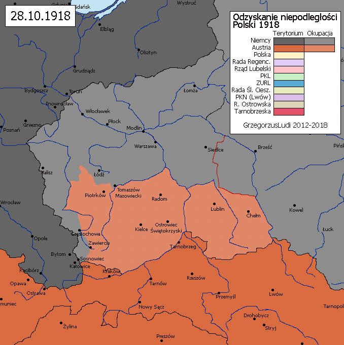
11/26/2022 at 7:29 AM GMT+5:30📌 18 | # 🌍┆general-chat

give an example

Why people view Orion negatively: Advertised his maps after a suicide announcement to the randoms who came on the server from the ping Is awful at taking criticism, countless times when he is criticized, he will just ignore it, and if the criticism is damning enough, he will pretend that he came up with it himself, still ignoring everyone else Is lazy with map-making, pretty much ignoring textual sources entirely, only relying on tracing maps and constantly asking people for shapefiles Made insensitive comments about religion, and posted maps from Lord of the Rings in #resources after I posted some Biblical maps that I had Huge ego, has many signs of narcissism and sociopathy Has gone after Pierre's suicidal nature with targeted comments Deflects any criticism with messages such as „lol”, which is a form of passive aggressiveness, and sometimes replies to something totally unrelated to try to divert the conversation, such as in one situation where he called a map I posted a while back „🤢” to try to deflect his present criticism Is frequently observed in debates trying to „recruit” the person who he believes is most likely onto his side through strange means Constantly asks people for help with various things in his maps that he is perfectly capable of doing himself Thinks he knows better than everyone else in a lot of topics, such as when he corrected an Arabic speaker on Arabic pronunciation, when he does not even know Arabic In the past, he has constantly spammed the DMs of people who clearly do not care with random things When someone answers somebody else's question, he repeats the answer that they gave right after, pretending that he came up with it himself * He keeps trying to speak in various foreign languages to people out of the blue, to try to appear smart and to make it so other people do not know what he is saying I could go on and on, but this should be enough
Starboard 1 APP
11/14/2022 at 9:49 AM GMT+5:30⭐ 1 | # 🗾┆real-mapping

Diadochus Vitellicus
list of diadochi rulers idk (part 1) Perdikkas: (lived 355-321/320 BCE, ruled 323-321/320 BCE) a noble from the Orestis royal family, and leader of the Hetairoi from 324 to 323 BCE, he was given Alexandros III's finger ring in his deathbed, so he was appointed as regent of the entire empire upon his death in 323 BCE. He campaigned in Asia Minor in 322 BCE to strengthen his authority. He married Nikaia, the daughter of Antipatros but broke off the engagement to try to marry Olympias, Alexandros III's mother, which caused a rebellion in Macedon and Egypt, which got him killed in 321/320 BCE Philippos III Arrhidaios: (lived 359-317 BCE, "ruled" 11 Jun 323 BCE-317 BCE) Mentally disabled half-brother of Alexandros III, he might have gotten disabled by a plot by Olympias, the mother of Alexandros III to make her child the only legitimate successor. After the death of Alexandros he was married to Eurydike, who effectively was more of a leader than him. He was killed in 317 BCE by Olympias of Epeiros in battle Neoptolemos: (lived ?-321 BCE, ruled 323-321 BCE) A hetairoi of the Epirote Aiakid dynasty, he got assigned Armenia upon the death of Alexandros, where he campaigned. He was then under Eumenes but betrayed him when he was on campaign against Krateros and Antipatros. He was killed in the Battle of the Hellespont, supposedly by Eumenes himself Krateros: (lived 370-321 BCE) A noble from Orestis, and phalanx commander through most of Alexandros III's campaigns, he was moving with 11,500 veterans to replace Antipatros as governor when Alexandros died. He crossed into Europe to help Antipatros in the Lamian War, acting as his general until getting killed in the Battle of the Hellespont by Eumenes' army Alexandros IV: (lived 323-309 BCE, "ruled" 317-309 BCE) Son of Alexandros III, he never got a chance to rule, even when the peace treaty of 311 BCE dictated he would be given rulership upon his adulthood. He was forced to take poison by Kassandros when he turned 14
Starboard 1 APP
11/12/2022 at 1:24 PM GMT+5:30⭐ 5 | # 🗾┆real-mapping

481: Theodoric Strabo dies, and so his domain is off the map. Every next mention of Theodoric is of Theodoric the Great. 482: Theodoric makes an offensive against the Romans in Greece reaching "as far as Larissa". 483: Theodoric makes peace with the Romans and is granted Dacia Ripensis and "parts of Lower Moesia". 484: Theodoric rules as council and kills Strabo's son Rekitach. 485: Nothing definitive; Theodoric and the Roman Empire are at peace. 486: Theodoric goes to war with the Romans again, "plundering Thrace". 487: Theodoric puts Constantinople under siege, but with no intent to take the city. 488: Theodoric returns to Novae-Svishtov, and is convinced to leave Thrace/Moesia for Italy by Emperor Zeno. Late 488: Theodoric kills Gepid King Thraustila at Sirmium and holds the city for a few months. 489: Theodoric marches through Pannonia to Italy.
Starboard 1 APP
10/27/2022 at 8:13 PM GMT+5:30⭐ 1 | # 🗾┆real-mapping
Pierricus Samniticus
-Paphlagonian kingdom -Isauria -Homonadeis -Isinda (likely but unconfirmed vassal of rome) -Termessos (definite roman "ally" vassal) -Pednelissos (Roman vassal) -Selge (probably independent but unconfirmed) -Kibyra (Roman vassal) -Oinoanda (Roman vassal) -Adada -Etenna -Kotenna -Halikarnassos -Sillyon -Derbe -Klitai (tribe) -Lalasis -Anemourion -Olbe (Roman vassal) -Troy (Roman vassal) -Lampsakos (Roman vassal)
Starboard 1 APP
10/27/2022 at 8:21 AM GMT+5:30⭐ 2 | # 🗾┆real-mapping
Pierricus Samniticus
Cretan League (all of crete) Phocian League Macedonian League Laconian League Delphic League (Delphi, Doris, Oetaea/Ainis, West Locris) Rhodes (Including a few settlements in the carian coast, Karpathos and that other island next to it) Euboean League Acarnanian League Delos Magnesian League Karthaia and Ioulis on the island of Keos Astypalaia Ephesos Priene Ptolemais/Lebedos Chios Erythrai Klazomenai Knidos Pergamon (with its port of Elaia) Mytilene Methymna Eresos Athens
Replying To Arnold Donald Thompson
please give me the enlightened knowledge
Starboard 1 APP
10/23/2022 at 3:21 PM GMT+5:30⭐ 1 | # 🗾┆real-mapping

CTCtheHistorian
481: Clovis begins his rule 486: Battle of Soissons; Syagrius defeated and later captured, but his holdings aren’t immediately captured. c.490: Almost all of Roman Gaul captured by the Franks, they reach the Loire. 491: Defeat and conquest of partial Thuringian territory. 492-498: Raids into Visigoth Gaul 496: Franks defeat Alemanni in the Battle of Tolbiac: As far as I’m aware, no territorial changes. 496: Paris finally falls to the Franks after holding out for ten years. 500-501: Burgundian Civil War; Clovis invades and sieges Avignon, but lifts the siege and returns home. 502: Meeting of “eternal peace” between Clovis and Alaric II (Visigoths). c.505: Romans convince Clovis to attack the Visigoths due to their heresy (they were Arians). 506: Franks defeat Alemanni at Strasbourg; the Alemanni completely abandon their homeland and the Franks claim it as theirs 507: Battle of Vouille, Visigoths defeated and Alaric killed. By winter Clovis is in Bordeaux 508: Toulouse captured by Clovis. 509: Theodoric’s Ostrogothic army under Theudis attacks and defeats the Burgundians and Franks in a few battles. Maybe around 509, I never got this far lol: Toulouse is briefly recaptured. 509: Clovis kills all of his rival kings and becomes the sole ruler of all Franks. 511: As far as I know, the Visigoths and Franks make peace. 27 Nov 511: Clovis dies, his kingdom being partitioned by his four sons.
Starboard 1 APP
06/01/2022 at 7:06 PM GMT+5:302 | # 🗾┆real-mapping

Diego I de Persia#5914
so to be short the leagues and states vassalized by rome were: Cretan League (created by Rome in 69 BC, abolished by Diocletian) Phocian League (created before historical record, abolished by Diocletian) Eleutherolaconian League (created by Augustus, abolished by Diocletian) Macedonian League (created by the Romans in 168 BC, abolished sometime in the 2nd century) Euboean League (created by Demetrios Poliorketes, abolished by Diocletian) Acarnanian League (created prior to the Peloponnesian War, abolished after the battle of Actium) Magnesian League (created after the Second Macedonian War, abolished by Diocletian) Aetolian League (created in the 4th century BC, abolished prior to the end of the Roman Republic) Athamanian League (created in 168 BC, abolished in 63 BC) Delphic Amphictyonic League (created before historical record, abolished by Hadrian)
Original
Starboard 1 APP
05/08/2022 at 2:30 AM GMT+5:301 | # 🗾┆real-mapping

Ollie Bye#5175
https://opendomesday.org/place/ @fabulous Dodolulupepe Ji 姬 I found this, might be useful to you.
Original
Starboard 1 APP
04/28/2022 at 8:40 AM GMT+5:30⭐ 6 | # 🇺🇦┆war-in-ukraine

Pierre (Dodolulupepe)
Frontlines that look like this are such a red flag
Starboard 1 APP
04/09/2022 at 8:15 PM GMT+5:301 | # 🗾┆real-mapping

Victorianius#7453
"In 40 AD, Caligula assembled 200,000 men at the Channel on the continent, only to have them gather seashells (musculi) according to Suetonius, perhaps as a symbolic gesture to proclaim Caligula's victory over the sea." I have doubts 200,000 men were assembed. Augustus demilitarized the army to around 168k men after the Roman civil war(And that would stay around that number for the next few centuries) so there can't had been so many legionnaires by the time of Caligula as that would leave basically the entire empire defenseless
Original
Starboard 1 APP
03/07/2022 at 4:36 AM GMT+5:301 | # 🔍┆research
Ollie Bye#5175
An alternative way of showing sparsely populated areas in the modern era.
Original
Attachments

Ollie Bye
Methodology
Abraxicus APP
02/10/2022 at 5:32 AM GMT+5:30
The name Ukraine is derived from the Old Russian kraj ("one's own land", "native land") and the suffix "u", which in combination means an antonym of the word chuzhbin - "someone else's land", "foreign land". While in Poland they usually used Okraina or Ukraine too as term for borderland.
Jump
Term "Ukraine" was used as a borderland of Polish-Lithuanian Commonwealth not Russia.
Jump
Starboard 1 APP
02/08/2022 at 10:00 AM GMT+5:301 | # 🗾┆real-mapping

Hetman#9122
You're not just converting into camtasia, youtube porcesses the image as well. Based on what I see, most details under 5 pixels (assuming a 4k definition) won't show at all or will be incredibly blurry.
Original
Starboard 1 APP
02/07/2022 at 6:48 PM GMT+5:301 | # 🗾┆real-mapping

A.S. Mapping#2854
and there are 3 other volumes by Ibn Athir which also talk about Seljuk history till the year 1231
Original
1 | # 🗾┆real-mapping
A.S. Mapping#2854
its about the history of Seljuks from about 1020 till 1096
Original
⭐ 1 | # 🗾┆real-mapping

A.S. Mapping
but make sure to look up "annals of the seljuk turks" by Ibn Athir, it has so much info which is not well known to most mappers
Starboard 1 APP
02/06/2022 at 4:14 AM GMT+5:301 | # 🗾┆real-mapping

POGKPP#2296
In July 1940, a mysterious supporter of peace, known as "Canute Bond" went with the support of Reich Marshal Hermann Göring to London and met with Edward Wood. During their talks, Lord Halifax argued that peace would be possible only if the Germans rebuilt the Polish state and created some undefined form of freedom for the Czechs. When Hermann Göring heard about these two basic conditions, he went to Hitler. The Reich Marshal later reported, "I went to the Führer and reported on the course of Bonde's visit to London. When I told about Lord Halifax's proposals Hitler replied 'A kind of Polish state - about this we can talk. But more liberties for the Czechs - is not possible at all".
Original
Starboard 1 APP
02/05/2022 at 6:00 PM GMT+5:301 | # 🌍┆general-chat

Linbot#6018
the only ones I would hold up as useful are the Second Revolution one, the Hungary one, the Polish-Ottoman conflicts, the Pruth War, and the Two-Liu War
Original
Abraxicus APP
01/24/2022 at 6:42 AM GMT+5:30
Iirc the Soviet general that seized the area after the fall of the Soviet Union offered that area to Germany and Lithuania (Poland was just ignored) but both countries rejected it.
Jump
Starboard 1 APP
01/04/2022 at 10:50 AM GMT+5:303 | # 🌍┆general-chat

tnt95lp#2074
And use regional maps and articles, books and etc. To use in your own research.
Original
3 | # 🌍┆general-chat
tnt95lp#2074
If you guys want advice on how to map and not overgeneralize, make your videos represent and show regional maps instead of making subcontinental and continental maps since it will be much more detailed and reliable for people who watch them.
Original
Starboard 1 APP
01/02/2022 at 9:40 PM GMT+5:301 | # 🌍┆general-chat

Antoninus#7453
What's the point of wasting hours of your time on something most of your audience isn't gonna see. It's a sad fact but most people just aren't gonna put on 0.25x speed and dissect all the wonderful things about this video, so why put it in the first place. Also the Roman Consul System is actually relatively muddy compared to what people think. The main list of roman consuls come from a guy named Marcus Terentius Varro(Apparently there are a lot of them).This list is only completely accurate by 300 BC, so from 509 BC to 300 BC. We aren't really sure if the Consul list is actually true and while this doesn't apply to this video as the Romans appear in the Balkans in the 3rd century, it is something to beware if you were to make a Rome video in general.
Original
Starboard 1 APP
01/02/2022 at 5:56 PM GMT+5:301 | # 🌍┆general-chat

luxtaythe2nd#0287
they call the Bay of Puck the Small Sea
Original
1 | # 🌍┆general-chat
luxtaythe2nd#0287
fun fact: the Kashubians call the Baltic Sea 'The Big Sea' (Wiôldzé Mòrze)
Original
Starboard 1 APP
01/02/2022 at 5:49 PM GMT+5:302 | # 🌍┆general-chat

Borysk5#1744
Fun fact, only 100s years ago Hel peninsula was series of islands
Original
Starboard 1 APP
01/02/2022 at 10:13 AM GMT+5:301 | # 🗾┆real-mapping
Algol#0523
ffmpeg is really chad at doing what videomappers need most: frames -> video
Original
Starboard 1 APP
12/29/2021 at 3:10 PM GMT+5:301 | # 🔍┆research

kdskdsk/A.D.T. Mapping#4305
Also, Mycenae (you show as Mi-ke-ne) would more accurately be "Mu-ka-na-i" or 𐀘𐀏𐀙𐀂 (this term is plural, like Athḗnai)
Original
1 | # 🔍┆research
kdskdsk/A.D.T. Mapping#4305
You could use the name of the island of Crete (as Minoan remains untranslated, the term is Mycenaean Greek) "ke-re-te"
Original
1 | # 🔍┆research
kdskdsk/A.D.T. Mapping#4305
Regarding the Minoan no-name problem
Original
Starboard 1 APP
12/18/2021 at 11:11 PM GMT+5:30📌 1 | # 🗾┆real-mapping
Are there even any accurate maps of medieval Italy?

https://hpolities.euratlas.net/ is pretty good for 1200 Voltaire's New Nightmare is pretty good for 1444 and my map is pretty good for 1453
Starboard 1 APP
12/17/2021 at 9:48 AM GMT+5:30⭐ 11 | # 🗾┆real-mapping
i tried my best making a map of "with detail, without detail, and fake detail"

Starboard 1 APP
12/16/2021 at 11:53 PM GMT+5:301 | # 🗾┆real-mapping

AbdurRahman (Doodlate)#4534
@User Not Found @RETF YOOO http://ktp.isam.org.tr/salname/sayilar.php?sidno=D02467 free PDFs of all (general) ottoman and turkish salnames from 1847 to 1929
Original
Starboard 1 APP
12/15/2021 at 10:56 PM GMT+5:301 | # 🔍┆research

Dodolulupepe#2781
"and specifically in 1430, when fourteen villages of Zagori, on the north-east of Ioannina, offered subjugation to sultan Mourat in return for a number of privileges, among which self-government was the most important. The villages of Western Zagori followed with respective privileges, such as autonomy and freedom of implementation of religious duties. In the 17th century, Eastern and Western Zagori were linked in an autonomous federation of 46 villages"
Original
Starboard 1 APP
12/15/2021 at 8:04 PM GMT+5:301 | # 🗾┆real-mapping
AbdurRahman (Doodlate)#4534
https://commons.wikimedia.org/wiki/File:Senussi_Map2.png
Original
Starboard 1 APP
12/15/2021 at 7:43 PM GMT+5:301 | # 🔍┆research
Dodolulupepe#2781
also @Ollie Bye I found it!!!! It's Zagori https://zagoriview.com/history/ This doesn't have the exact date but I know it's there somewhere, I've found it before
Original
1 | # 🗾┆real-mapping
kdskdsk/A.D.T. Mapping#4305
upgraded my nuraghe thingy
Original
1 | # 🗾┆real-mapping
kdskdsk/A.D.T. Mapping#4305
Starboard 1 APP
12/10/2021 at 5:35 PM GMT+5:301 | # 🗾┆real-mapping
kdskdsk/A.D.T. Mapping#4305
1 | # 🗾┆real-mapping
kdskdsk/A.D.T. Mapping#4305
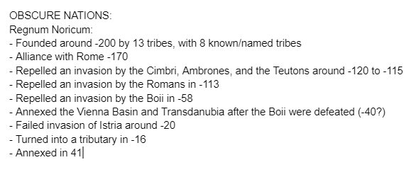
https://www.unrv.com/provinces/noricum.php
Original
1 | # 🗾┆real-mapping
kdskdsk/A.D.T. Mapping#4305
> Around 200 BC, thirteen tribes merged under the leadership of the Noricians to make up the Kingdom of Noricum. Thus, the Regnum Noricum is the first known political entity on the territory of today's Austria. Of the 13 tribes of Noricum, eight tribes are known by name through the excavations on the Magdalensberg: Alums, Ambidraves, Ambilines, Ambisontes, Laiankers, Norics, Saevates and Uperaks. - Noricum, German Wikipedia
Original
Starboard 1 APP
12/09/2021 at 8:14 AM GMT+5:301 | # 🗾┆real-mapping
Dodolulupepe#2781
and here's the 1535 full treaty text if anyone needs it (the treaty that abolished welsh marches, Laws in Wales act) https://books.google.com/books?id=do1KAAAAYAAJ&pg=PA243#v=snippet&q=hundred&f=false
Original
Starboard 1 APP
12/08/2021 at 9:28 PM GMT+5:301 | # 🌍┆general-chat
luxtaythe2nd#0287

1 | # 🌍┆general-chat
luxtaythe2nd#0287
I have a file named polski.txt on my computer that describes all the changes from old to modern Polish
Original
Starboard 1 APP
12/08/2021 at 7:04 PM GMT+5:30📌 1 | # 🗾┆real-mapping

https://docs.google.com/document/d/1Xv4IBB6POGhZmxJuDazT7M5_Y9QkW8AeBqAza7y4kZU/edit?usp=sharing
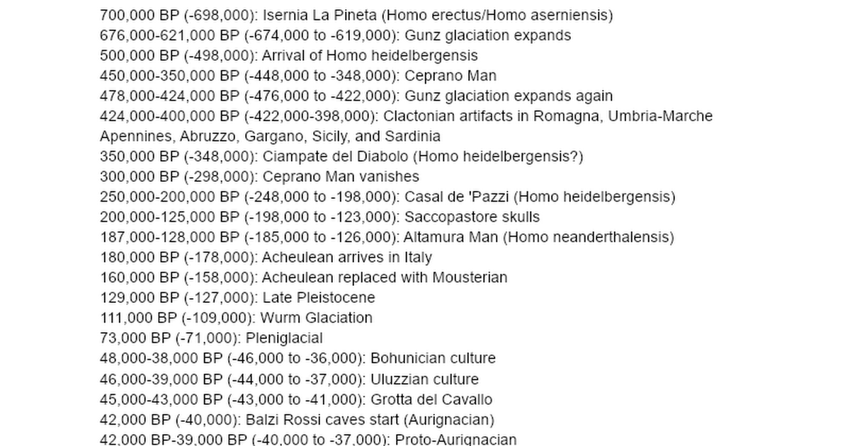
Prehistoric cultures: 1,500,000 BP (-1,498,000): Pirro Nord site (Oldowan industry, Homo erectus?) # could be Homo antecessor 1,300,000 BP (-1,298,000): Pirro Nord abandoned 850,000 BP (-848,000): Ca' Belvedere site (Oldowan industry, Homo erectus?) # could be Homo antecessor 700,000 BP (-698,00...
1 | # 🗾┆real-mapping
kdskdsk/A.D.T. Mapping#4305
Original
Starboard 1 APP
12/05/2021 at 11:55 PM GMT+5:301 | # 🗾┆real-mapping
POGKPP#2296
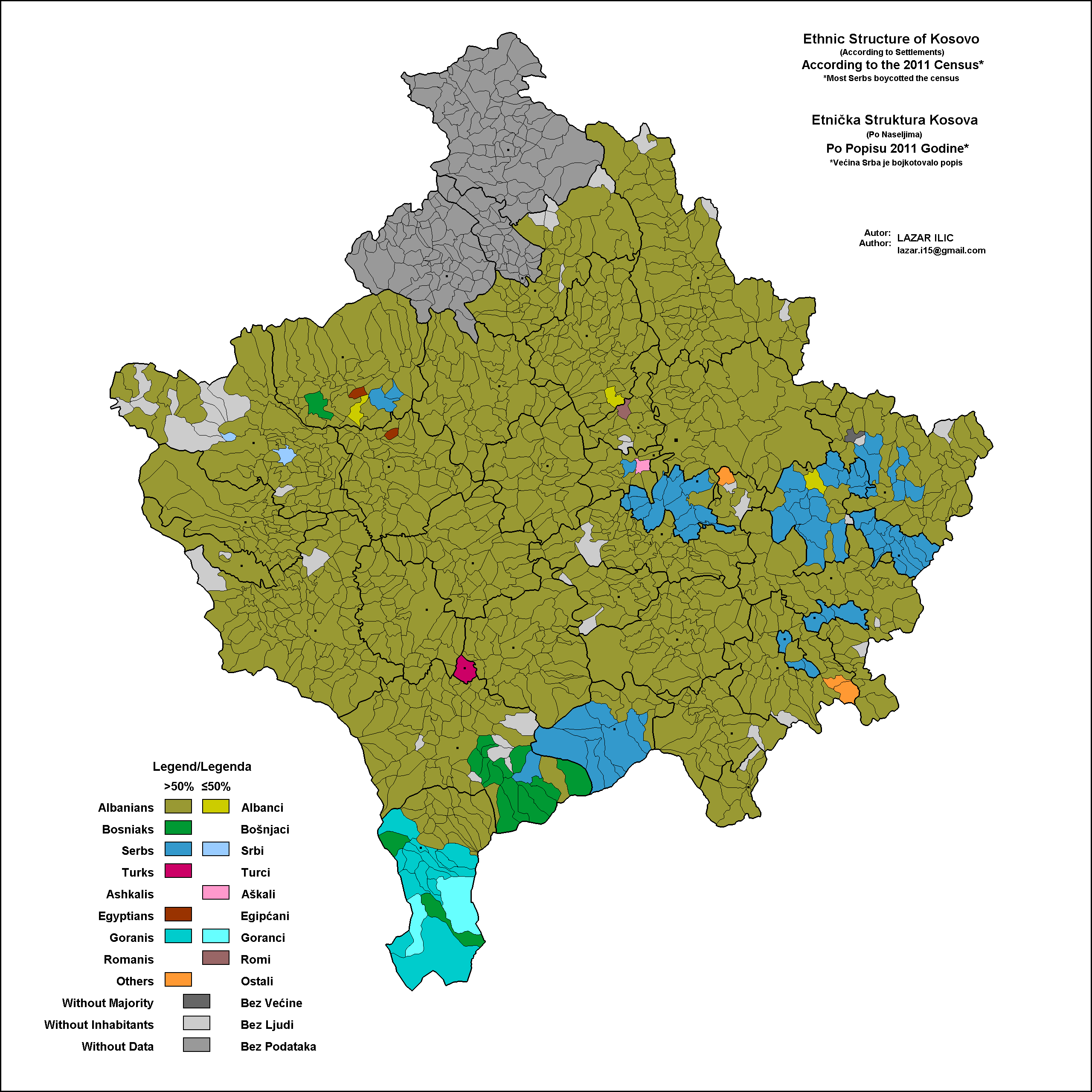
idk if anyone cares but the only region where ancient egyptians are majority to these days is in this one kosovian province in pink color. (Ashkalis) They migrated there in times of Ramesses II and somehow life there to this day. https://upload.wikimedia.org/wikipedia/commons/b/b8/Map_of_ethnic_groups_in_Kosovo%2C_2011_census.gif
Original
Attachments
Starboard 1 APP
12/04/2021 at 7:18 PM GMT+5:301 | # 🗾┆real-mapping
AbdurRahman (Doodlate)#4534
*Ottoman Algeria* CONSTANTINE: skikda, bejaia, batna, costantine, setif ALGIERS: chlef, algiers, milyana ORAN: oran, mostaganem, sidi bin abbas, "ahdar (mountain)" TITTERI: idk
Original
Starboard 1 APP
12/03/2021 at 4:54 PM GMT+5:302 | # 🗾┆real-mapping
AbdurRahman (Doodlate)#4534
Ottoman Egypt ---> Egyptian Sudan / Region of Sudan >>> - Berbera (1865 directly Egyptian) - Khartoum (also capital of Egyptian Sudan) - darfur (capital at fashir) - ulya-yi-nil / upper nile (capital at Ibrahimiya) - taka (capital at kessala) - kordofan (capital at ubayyid) - Bahr el gazal (capital at meshrerrek/meshr el rek) - safar - sennar - Bahr ul abyaz (capital at tawfikiya) - dongola
Original
Starboard 1 APP
12/03/2021 at 9:14 AM GMT+5:301 | # 🗾┆real-mapping
kdskdsk/A.D.T. Mapping#4305
1st Military Territory - September 9, 1891 to June 20, 1905 2nd Military Territory - August 20, 1891 to January 1, 1906 3rd Military Territory - August 20, 1891 to September 17, 1895 (divided into the provinces of Tuyen Quang, Bac Quang and Ha Giang.) 4th Military Territory - March 1886 or January 7, 1899 (wording is weird) to July 12, 1907
Original
Starboard 1 APP
12/02/2021 at 10:37 PM GMT+5:301 | # 🗾┆real-mapping
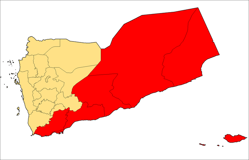
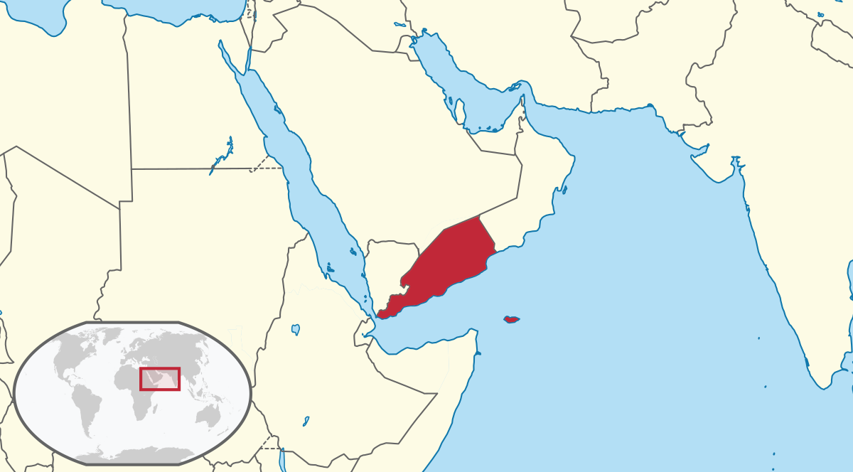
AbdurRahman (Doodlate)#4534
Original
📌 1 | # 🗾┆real-mapping

The South Yemeni Civil War, colloquially referred to as The Events of '86 or The Events of January 13, or more simply as The Events, was a failed coup d'etat and armed conflict which took place on January 13, 1986 in South Yemen. The civil war developed as a result of ideological differences, and later tribal tensions, between two factions of th...
📌 1 | # 🗾┆real-mapping
1 | # 🗾┆real-mapping
kdskdsk/A.D.T. Mapping#4305
A History of Kigezi in South-West Uganda, Donald Denoon (courtesy of jstor)
Original
Attachments
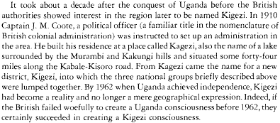
1 | # 🗾┆real-mapping
kdskdsk/A.D.T. Mapping#4305
> The country was put under the governance of Buganda administrators. The Banyoro revolted in 1907; the revolt was put down, and relations improved somewhat. After the region remained loyal to Great Britain in World War I a new agreement was made in 1933 giving the region more autonomy. - Bunyoro, English Wikipedia
Original
1 | # 🗾┆real-mapping
kdskdsk/A.D.T. Mapping#4305
> However, in 1899 Omukama Kabalega was captured and exiled to the Seychelles, and Bunyoro was subsequently annexed to the British Empire. Because of Bunyoro's resistance to the British, a portion of the Bunyoro kingdom's territory was given to Buganda and Toro. - Bunyoro, English Wikipedia
Original
1 | # 🗾┆real-mapping
kdskdsk/A.D.T. Mapping#4305
> On 25 October 1901, the Kingdom of Nkore was incorporated into the British Protectorate of Uganda by the signing of the Ankole agreement. - Ankole, English Wikipedia
Original
fabulous Dodolulupepe Ji 姬
pannonia still existed as a puppet of the franks but an independent Balaton replaced it later
Abraxicus
more info on Balaton/Pannonia inferior in following messages
Starboard 1 APP
11/29/2021 at 7:42 PM GMT+5:301 | # 🗾┆real-mapping
POGKPP#2296
Balaton is the only real name and they weren't puppet of franks
Original
Starboard 1 APP
11/23/2021 at 5:26 AM GMT+5:30📌 1 | # 🗾┆real-mapping
Starboard 1 APP
11/13/2021 at 12:31 PM GMT+5:301 | # 🗾┆real-mapping
kdskdsk/A.D.T. Mapping#4305
1 | # 🗾┆real-mapping
kdskdsk/A.D.T. Mapping#4305
Original
1 | # 🗾┆real-mapping
kdskdsk/A.D.T. Mapping#4305
Starboard 1 APP
11/10/2021 at 8:32 AM GMT+5:301 | # 🗾┆real-mapping
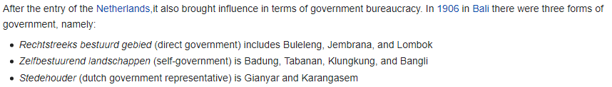
kdskdsk/A.D.T. Mapping#4305
Bali Kingdoms status c. 1906
Original
Attachments
Starboard 1 APP
11/09/2021 at 10:42 PM GMT+5:301 | # 🗾┆real-mapping
kdskdsk/A.D.T. Mapping#4305
Chiang Mai - 1899 Mae Hong Son - 1903 or 1907 Lamphun - 1907? Lampang - 1892 Phrae - 1897 (there was a rebellion in 1902 too) Nan - 1899 Chiang Rai - 1910
Original
Starboard 1 APP
10/28/2021 at 10:01 PM GMT+5:301 | # 🗾┆real-mapping

dectec#4382
That's sort of retreading on what we already established, but interpreted in a different way. I suppose we can put it this way, cartography has gone from a highly prestigious — almost entirely professional field in the 19th and 20th centuries — into more of a hobby in the 21st century as all the tools needed to create a high quality map can be downloaded for free online alongside most information can be found online. Additionally, high quality maps are no longer in as high demand as they used to be, alongside those able to make such high quality maps would have increased as technology regarding mapping had. Thus, less demand and more competition would inevitably lead to a collapse of what was once a prestigious industry with an extremely high skill barrier of entry into something that tens of thousands (or hundreds of thousands? I don't know how large the worldwide online mapping community is these days, as its always growing) of mostly unskilled individuals partake in daily as a hobby which is most often done free of charge. Which obviously circles back to the reason why map quality has decreased on average overall.
Original
Starboard 1 APP
10/28/2021 at 8:23 PM GMT+5:301 | # 🗾┆real-mapping
dectec#4382
You're correct to a degree, mapping quality on average has dipped rather significantly. Yet despite this, arguably some of the best cartographers in all of human history are living and breathing right now, and many more are still yet to come, but overall maps are becoming on average rather... Lacklustre, to say the least. With that said, that does not discredit my summary of the issue, which if expanded upon would've covered such points, but I don't feel like writing an essay on the online mapping community of all things. A possible reason for the decrease in mapping quality could be oversaturation and the tools required to create maps being put in the hands of anyone who has a computer nowadays. Mapping templates such as QBAM and MBAM have most definitely expanded the reach of the online mapping community, although both of these two extremely popular base maps are fundamentally flawed projections, which really doesn't help, which is only one issue of many of such projects. Despite all this, it is important to recognise that for every 10,000 QBAM maps, there are individuals like Yan Xishan who continuously push the boundary for what is considered a good map (video). Yan's 'The History of 20th Century Tibet: Every Day' is far beyond what any cartographer of the 19th and 20th century could've ever dreamed creating. Which brings me to my next and most important point. How is it that we are in an era where there is an unquantifiable degree of the worlds knowledge and information is all at our fingertips, and in addition to that we have the capabilities to make maps of an accuracy that would be unfathomable to the cartographers just a hundred years ago, yet mapping quality has seen a sustainably decline in quality and accuracy on average, both from professional cartographers and hobbyists? I could answer this question, but I would prefer to leave it open for you all to make your minds up on what you think.
Original
Starboard 1 APP
10/28/2021 at 8:16 PM GMT+5:301 | # 🗾┆real-mapping
AbdurRahman (Doodlate)#4534
lecce 812-842 brindisi 838-870 taranto 840-842 on it's own, 842-about 880 subservient to emirate of Crete? reggio calabria 901-905 tip of garigiliano 882-915, first subservient to aghlabids then to fatimids benevento 842-849 bari 841-876, maybe kinda or nominally subservient to aghlabids but also officially and nominally a governorship of the abbasid caliphate this is all of the independent entities in the Italian peninsula maybe minus some encampments near Rome and Latium, occupations and conquests by aghlabids aren't mentioned here
Original
Starboard 1 APP
10/28/2021 at 11:45 AM GMT+5:301 | # 🗾┆real-mapping
kdskdsk/A.D.T. Mapping#4305
Starboard 1 APP
10/28/2021 at 6:43 AM GMT+5:30📌 1 | # 🗾┆real-mapping

Starboard 1 APP
10/26/2021 at 9:54 PM GMT+5:301 | # 💁┆legacy-mapping-help

POGKPP#2296
BTW. If someone don't know how to correctly show occupations in medieval periods I know one way for it. I've heard that already many times from historians and videos. I think it can be useful for some mappers. Many roads especially in some less populate areas didn't changed through the years, and by tracing a map of German Empire from 19th century with roads included, you can easily reconstruct roads many centuries back, to the times where larger settlement started in this place. Then you just follow descriptions when town A and town B were occupied, and see which one of roads connects them. If there are several roads, some descriptions have information whether army crossed some lake, or made a camp somewhere.
Original
Abraxicus
^ scroll down for error corrections
Starboard 1 APP
10/24/2021 at 9:57 PM GMT+5:301 | # 💁┆legacy-mapping-help

Orion#2595
Timeline of major Romanian border changes since 1683:
Original
Attachments

1 | # 💁┆legacy-mapping-help
Orion#2595
Made a list of Czechoslovak border changes. A lot of them in a few years. Anyone know if there were any I missed here?
Original
Attachments

Starboard 1 APP
10/23/2021 at 9:02 PM GMT+5:301 | # 🗾┆real-mapping

SuреrPоореr#2085
amami 奄美 Izu Oshima 伊豆大島 Yaeyama 八重山 Republic of Oshima 大島共和国 Yaeyama Residents' association 八重山自治会or Republic of Yaeyama 八重山共和国 Amami People's Republic 奄美人民共和国
Original
Starboard 1 APP
10/23/2021 at 7:36 PM GMT+5:301 | # 🗾┆real-mapping
SuреrPоореr#2085
links he sent after i messaged him for further info https://ja.m.wikipedia.org/wiki/%E5%A5%84%E7%BE%8E%E5%85%B1%E7%94%A3%E5%85%9A http://oisr-org.ws.hosei.ac.jp/images/oz/contents/510-3.pdf https://ja.m.wikipedia.org/wiki/八重山自治会 https://yaimatime.com/yaima_special/27125/ https://core.ac.uk/download/pdf/71786552.pdf https://ja.m.wikipedia.org/wiki/大島大誓言 http://www2.ngu.ac.jp/uri/syakai/pdf/syakai_vol4904_08.pdf
Original
Starboard 1 APP
10/23/2021 at 5:25 AM GMT+5:301 | # 🗾┆real-mapping

Abraxicus#2482
I don't think there are really many regions that are virtually independent However, Yaeyama was virtually independent and self-governing. (They didn't want to be independent, but the surrender of Japan made them anarchy and they created an autonomous organization.) Also, Izu Oshima enacted a constitution, and in the Amami Islands, Communists tried to create an independent country. (They haven't gained independence after all) from: same guy
Original
Starboard 1 APP
10/23/2021 at 5:16 AM GMT+5:301 | # 🗾┆real-mapping
Abraxicus#2482
Izu Ōshima 伊豆大島 いずおおしま They enacted a constitution in an attempt to become independent when Japan was defeated in World War II. But they soon stopped becoming independent. I think, it probably not very well known in the English-speaking world. from: kissing 💋 gourami#5503
Original
Attachments
fabulous Dodolulupepe Ji 姬
specifically the Mongol banners
Abraxicus
info on Qing territory hierarchy
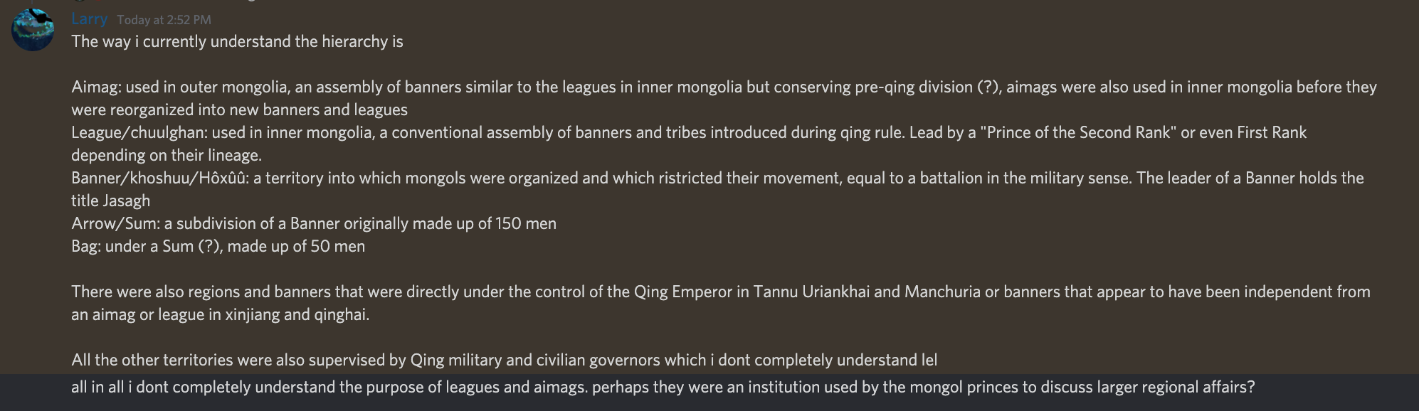
fabulous Dodolulupepe Ji 姬
terrain generator ^
Starboard 1 APP
10/14/2021 at 11:13 PM GMT+5:30📌 5 | # 🗾┆real-mapping

http://elasticterrain.xyz/map/ If anyone else wants to use it.
Starboard 1 APP
10/06/2021 at 9:26 PM GMT+5:302 | # 🗾┆real-mapping

POGKPP#2296
In polish afoe community it also started like that, then they added countryball templates, map templates, eye templates, thumbnails templates, etc... And it made people extremely lazy and their videos were garbage. And now guess what? It's dead. This community dosen't exist right now, there are just few channels with maximum amount of 1000 views, which is nothing compared to avrage 200k views in golden era. Interprate it as ironic comparision, but also be aware of it.
Original
Starboard 1 APP
10/06/2021 at 8:25 PM GMT+5:301 | # 💁┆legacy-mapping-help

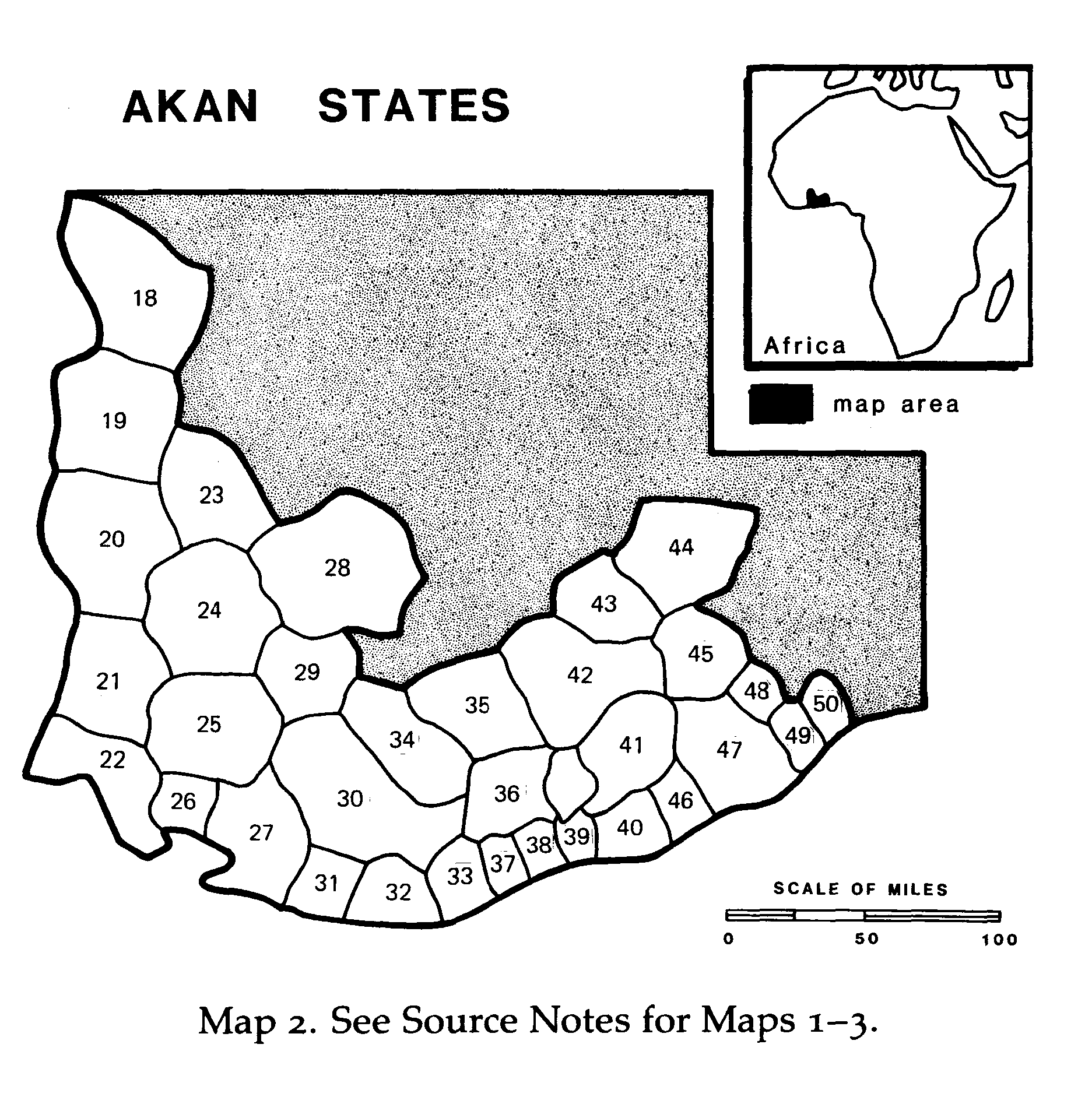
RETF#9250
Map of the Akan states before the rise of the Ashanti empire in Ghana and parts of Togo and the Ivory Coast according to the book "Africa and Africans in the making of the Atlantic world 1400-1800" 18- Shabanda (Xabanda) 19- Usho (Uxoo) 20- Inkasa Igwiya (Caceres Aguines) 21- Aowin (Famba) 22- Asoka (Bagno) 23- Labore 24- Wassa 25- Egwira (Alderrada/Groot Inkasser) 26- Axim 27- Ampira (Ampago) 28- Boennoe 29- Kwifero 30- Adom (Semsee) 31- Ahanta 32- Cape three points 33- Sabeu 34- Abrem (Abramboe) 35- Assin (Acanes Pequenos/Akanji) 36- Etsi (Atins/Atij) 37- Komenda (Comane/Commendo) 38- Futu (Futo/Affuto) 39- Sabu 40- Fante (Fantin) 41- Akwame (Abramboe) 42- Akyem (Acanes Grandes/Akim) 43- Akan 44- Tafo (Tafoe) 45- Abuna (Abaans/Bonoe) 46- Aguano (Biambi) 47- Accra (Cracra) 48- Latebi (Latebij) 49- Labidi (Labidan) 50- Ningo Date: 1625 A.D., 17th century A.D.
Original
Attachments
Ghana_states_map_see_Africa_and_Africans_in_the_making_of_the_Atlantic_world_1400-1800-1.png
Starboard 1 APP
09/30/2021 at 5:40 AM GMT+5:301 | # 💁┆legacy-mapping-help

kailanmapper#7003
Also the Ottomans and Iranians disputed over a bunch of minor territories
Original
Starboard 1 APP
09/28/2021 at 5:35 AM GMT+5:301 | # 💁┆legacy-mapping-help
Ollie Bye#5175
http://www.chengfolio.com/google_map_customizer#administrative/labels/444444/off/administrative.country/geometry.stroke/444444/off/administrative.province/geometry.stroke/444444/off/landscape.man_made/geometry/e2d9a5/on/landscape.natural/geometry/719d46/on/poi/all/444444/off/road/geometry/ffffff/on/road/labels/444444/off/transit/labels.icon/444444/off/transit/geometry/444444/off/transit/labels.text/444444/off/transit/geometry/444444/off/transit/labels/444444/off/water/geometry/92bcdc/simplified/water/labels/444444/off/landscape.natural/labels/ffffff/off/administrative/geometry/000000/on This thing TDH sent me. It can give you a good overview of the shape of an urban area.
Original
Starboard 1 APP
09/28/2021 at 5:06 AM GMT+5:301 | # 💁┆legacy-mapping-help
RETF#9250
Keep in mind that the tarki shamkhalate existed too the green one in the dagestani coast
Original
Attachments
Starboard 1 APP
09/27/2021 at 8:52 PM GMT+5:301 | # 💁┆legacy-mapping-help
POGKPP#2296
Explanation of Silesian problem made by historian: (Translated in DeepL) The extent of freedom of the rulers of the principalities seems considerable. Each had its own finances (although part of the income was transferred to the king or the emperor), issued its own contingents, so at least in part they had separate armed forces. The princes (although they needed consent) at their own discretion divided the lands subordinate to them, minted their own coinage, and decided what religion could be practiced on the territories subordinate to them. At the same time, the Silesian Dukes held high offices in Prague and Vienna, so their relationship with the monarchy was multifaceted. Seeing that the history of individual principalities was different, e.g., those hereditary (Świdnickie, Jaworskie, Głogowskie and Wrocławskie) were strongly recatholicized, while in others (Legnickie, Brzeskie) Protestants had freedom of religion. The history of Oleśnickie (composed of smaller district-princes: Oleśnicka, Bierutowska and Dobroszycka) is strongly connected with successive dynasties: Piasts, Podiebrads and Wirtembergs, each of these families gave a different character to the lands they ruled, they maintained contacts with various courts, made alliances and brought artists. Let us not forget the unusual creation of the Duchy of Nysa, ruled by the Bishop of Wroclaw. Imagine a situation where the political, administrative and probably also judicial head was a clergyman at the same time! Observing the influence of the division into principalities in the field of architecture, which is not highly politicized, I can assume that for such fields as legislation or judiciary was very important.
Original
Starboard 1 APP
09/27/2021 at 12:48 AM GMT+5:301 | # 🌍┆general-chat

Linbot#6018
one of my favourite pieces of forgotten history is when the Mamelukes declared independence from the Ottomans for seven years in the 18th century
Original
Starboard 1 APP
09/26/2021 at 12:32 AM GMT+5:301 | # 💁┆legacy-mapping-help
POGKPP#2296
Found another Silesian stuff to discuss 😄 ! Some guy who aspires to be a historian and attends history studies, send me this https://jbc.jelenia-gora.pl/dlibra/show-content/publication/edition/16796 and said that my video about Silesia missed some principalities, in late centuries where most of us agree that they lost autonomy. When I told him about that, he said that administrative situation in Silesia was much more complicated than just principalities losing autonomy, and he also said that this publication should explain everything. I'm still looking for more info, but I decided to post it here as well, because everyone loves Silesian Principalities in this server.
Original
Starboard 1 APP
09/23/2021 at 5:16 PM GMT+5:301 | # 🗾┆real-mapping
kdskdsk/A.D.T. Mapping#4305
addendum: It wasn't always a constant 104m till 1976 with the Siofok sluice system
Original
Starboard 1 APP
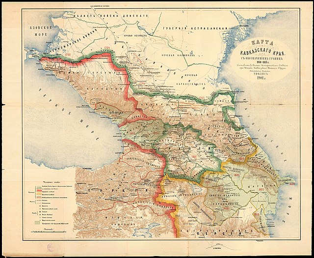
09/23/2021 at 4:20 PM GMT+5:30📌 3 | # 🗾┆real-mapping
Notice to all people showing Lake Balaton: Beware of the 19th century artificial water lowering (if you're wondering when it was lowered, it was when the Sio lock opened in 1863)

Starboard 1 APP
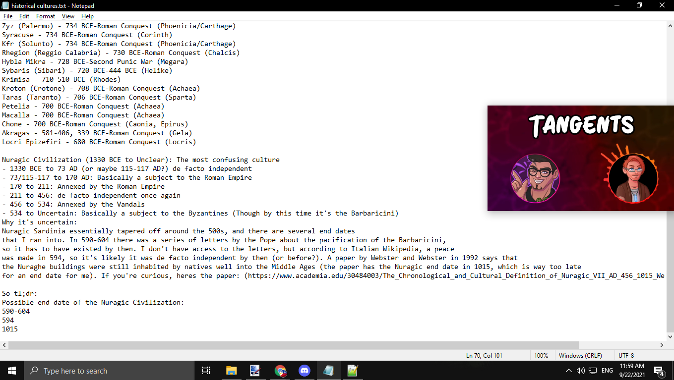
09/22/2021 at 9:41 AM GMT+5:301 | # 🗾┆real-mapping
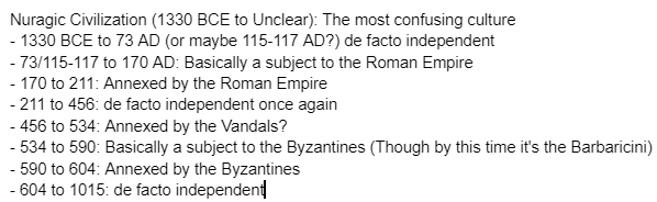
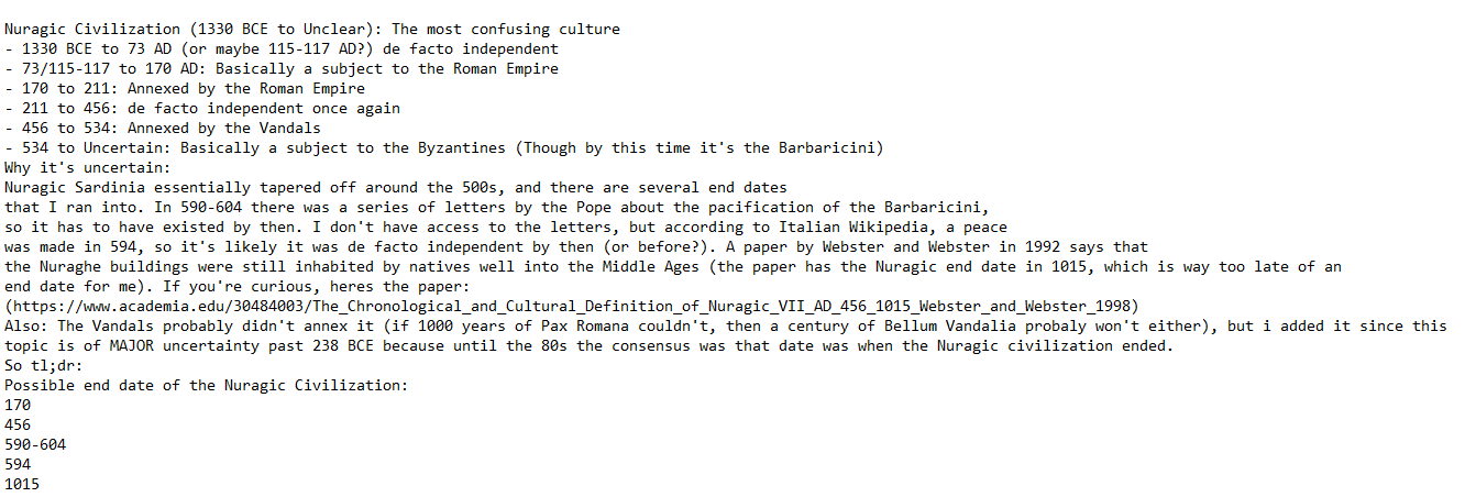
kdskdsk/A.D.T. Mapping#4305
re: the Nuragic Civilization
Original
Attachments
Davidmin
The bot has a bug
Davidmin
This should say "the capital fell exactly seven years after Constantinople", not "seven days", BTW.
Starboard 1 APP
09/21/2021 at 4:48 AM GMT+5:303 | # 🗾┆real-mapping
Dodolulupepe#2781
Morea was quite different from other Roman rump states like Trebizond and Epirus, as it was a direct part of the Empire, as a core province of it. When Constantine XI died, the ruler(s) in Morea became the de facto emperors, because under the peace treaty, the Roman Empire's holdings in Morea remained unchanged (as a tributary of the Ottomans, though). They failed to pay tribute, and were invaded in 1460. The capital surrendered exactly seven years after Constantinople. It still counted, officially, as a Roman or ""byzantine"" (I hate that name but that is how some people call it) province. Think of it as separate administrative levels. Before the Fall, the Roman Empire consisted of two administrative provinces: Constantinople and Morea. Both were under the Empire, as provinces. When Constantinople fell, Morea became the only province left. So the country became both Morea (because it was the only province), yet was still the Roman Empire. It was basically two levels of titles, superimposed upon each other. The Roman Empire now became only the Despotate of Morea, so either name is interchangeable, because Morea is the only second-level center of governance left. Medieval naming is weird.
Original
Starboard 1 APP
09/20/2021 at 10:36 PM GMT+5:302 | # 💁┆legacy-mapping-help

French ball Mapper#0506
if anyone needs help with Mapping on mobile, ask me
Original
Starboard 1 APP
09/03/2021 at 10:16 AM GMT+5:301 | # 🗾┆real-mapping
RETF#9250
BTW one thing, the hawwara actually extended through Makuria's territory
Original
Starboard 1 APP
09/03/2021 at 8:31 AM GMT+5:301 | # 🗾┆real-mapping
kailanmapper#7003
Also the Assyrian map might be relevant to that time period believe it or not, because these tribes were basically independent after the fall of assyria
Original
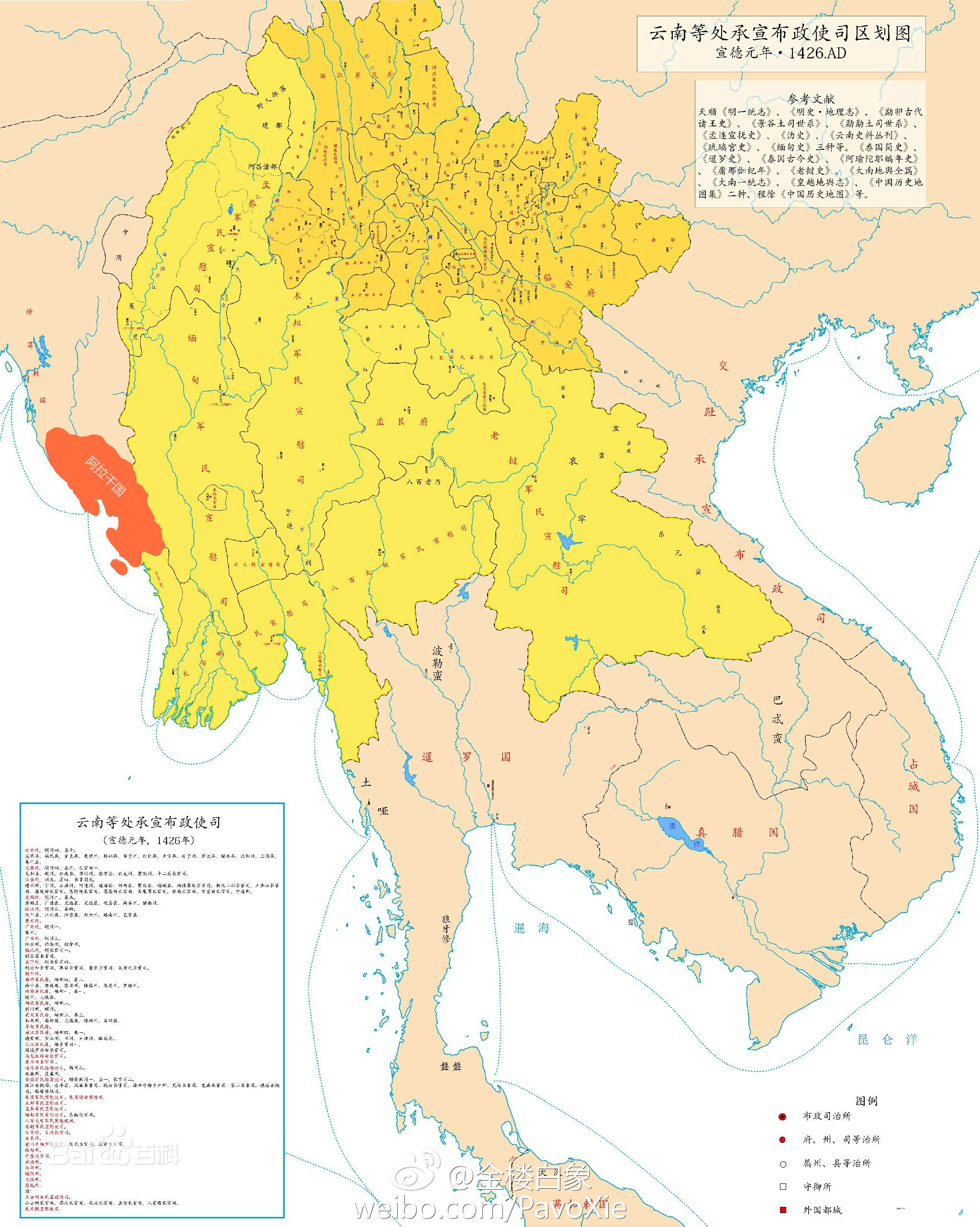
fabulous Dodolulupepe Ji 姬
southeast asia in 1426 ^ muang phuan is missing borders in the vietnam-cambodia inbetween area are probably wrong but apart from that, great map
Starboard 1 APP
08/31/2021 at 9:48 AM GMT+5:301 | # 💁┆legacy-mapping-help
Algol#0523
Original
Attachments
Starboard 1 APP
08/27/2021 at 8:54 PM GMT+5:30⭐ 10 | # 🗾┆real-mapping

I saw before on this server some theses that bad and wrong mapping videos can affect science and peoples knowledge. And also some time ago my parents accidentally discovered my youtube chanel. One of them, my dad is professional historian. And he said that some professors and historians are using these videos commonly as a visualisations and "modern kind" of sources especially during an academic lecture. So yes, this theory is true. Bad mapping videos can affect science or at least knowledge of professionals when they are not careful enough...
Starboard 1 APP
08/22/2021 at 12:50 AM GMT+5:30📌 1 | # 🗾┆real-mapping
Starboard 1 APP
08/21/2021 at 11:45 PM GMT+5:30📌 1 | # 🗾┆real-mapping

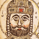
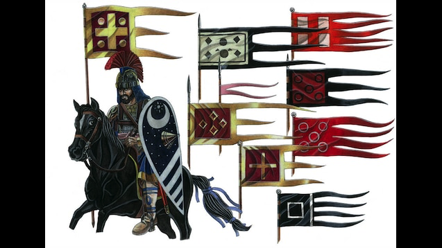
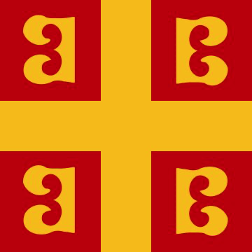
900s-1204 byzantine/ere flag > The flag here consists of the Roman flag that had been used since the abandonment of the Khi-Rho standard started by Constantine I, a red banner and a golden cross, which later had four golden X's added to it (these being the Greek K's, they relating the Khristos, or Christ), then the X's were replaced by four golden circles (the edition used in the mod). If anyone knows what these circles may have symbolized, please let me know. Other flags in the picture above are military flags, save the one with the golden cross. > > Upon the recapture of Constantinople by Greco-Roman Nikaean forces in 1261, the revived Empire of the Romans under the Palaiologos dynasty (this second Roman Empire essentially being a Greek kingdom) had its flag updated to the more recognizeable edition with the four B's. This B flag design was also found dating to the early pre-Sack 1200's, meaning that perhaps someone during the reign of the Angelos dynasty was already making designs for the future adopted flag. -- from: https://steamcommunity.com/sharedfiles/filedetails/?id=1580336657
1 | # 🗾┆real-mapping

Abraxicus#2482
palaiologos family, "greek" misconception > House Palaiologos, then spelt Palaeologus (keepers of old relics) > At some point they lived in Armeniakon (same land that house Komnenos and Makedon originated from) and it is thought that their house symbol of a double-headed eagle came from there. > > Near the end of the Palaiologus period, Emperors began treating their realm as more of a kingdom and not pressing old 'world empire' propaganda, even allowing citizens to call themselves Greeks, this previously being banned as Greek was a term used only for the old pagans of the land and Roman referred to its christian period; it is for this reason why the ignorant misunderstand and apply this policy to the whole length of the Roman Empire ever since Odacer took Italy. -- from: https://steamcommunity.com/sharedfiles/filedetails/?id=1051486815
Original
📌 1 | # 🗾┆real-mapping
latin empire, 1261 ere/byzantine flag > The 'Empire of Romania', better known as the so-dubbed 'Latin Empire' or 'Latin Occupation', actually styled themselves as a foreign dynasty of Rhomania but in reality had abandoned all old policies and traditions, treating their realm as a western kingdom instead of following Roman ways, and it is for this reason that they are remembered as a different state. Despite the Papacy excommunicating those who participated in the 4th Crusade, they were legitimized when allowed to participate in one of their many church councils, making such punishment moot. > > On 1261, Michael took back the holy capital from the 'barbarians', and announced that the true Roman Empire had been restored, taking the title of Basileus Mikhael VIII (8th) of the Palaiologos dynasty. Upon doing so, he knew that the Catholics of the West might retaliate, so he changed the old flag of the Roman Empire (as designed by Constantine the Great) and made it an adaptation of the Latin Empire flag, removing the many star-like croses with four betas. He also sent bishops to attend some Catholic councils, the first time east and west doing this in centuries. He went too far in trying to appeal to the Papal West, however, for when he began adapting western traditions (both civil and religious), many of his own subjects felt betrayed and went over to serve Rum so that they may have vengeance upon this 'tyrant'. image: find a higher quality one (more pixels) -- from: https://steamcommunity.com/sharedfiles/filedetails/?id=1051486815
Starboard 1 APP
08/21/2021 at 11:28 PM GMT+5:30📌 2 | # 🗾┆real-mapping
info on byzantine/eastern roman/ere flags image: more historically accurate to have it without the golden wreath > The Khi-Rho flag fell out of use following the 6th Century, then being replaced by a red banner witha gold cross. This would later have Greek χ's be put in the empty red pockets (these standing for Khristos, or Christ); Then for some reason they switched to gold circles. Roman Emperor Romanus II Diogenes made a new design but after his defeat at Manzikert that was abandoned due to the perceived taint his defeat had on the flag. Going back tot he variant with four circles, it would continue to be sued until the fall of the Roman Empire in 1204, its 1261 resurrection giving a newer design with the recognizable four B's. > > > Use of the Labarum Chi Rho flag started duiring the rise of Constantine the Great just before the Battle of Milvian Bridge in 312 and officially became the flag of the Roman Empire with the end of the Tetarchy and the cementing of the Dominante government system (Emperor having unlimited power) in 325. It would fall out of fashion after the 500's > Imperial double eagle > It was historically never used as a national flag for the Roman Empire, but it was the dyastic symbol for the Palaiologos dynasty. After 1453, the East Orthodox Church used the symbol to show their closeness to the historical Roman Empire with it's last dynasty, and it would later play an important role in propaganda symbolage by the Russian Empire. > design proposed by Romanos II > https://en.wikipedia.org/wiki/Romanos_IV_Diogenes#Campaign_of_1069 > "" ...depicts a cross quartered with the letters ϹΒΡΔ for the motto Σταυρὲ σου βοήθει Ρωμανόν δεσπότην ("Thy Cross aid the Lord Romanos")."" > The Chi-Rho was actually sometimes used alongside wreaths. -- from https://steamcommunity.com/sharedfiles/filedetails/?id=933739300

Starboard 1 APP
08/20/2021 at 12:35 AM GMT+5:301 | # 💁┆legacy-mapping-help

Dsfisher#2949
The fact that those get recognized as kingdoms, but massive African Empires are often still referred to as tribes fucking sickens me
Original
Starboard 1 APP
08/18/2021 at 8:18 AM GMT+5:301 | # 🗾┆real-mapping
Dsfisher#2949
Spiegelberg came to the Westphalia in 1810, and the Vienna Congress (1815) brought the county back to the Nassau-Oranien (Netherlands). But already in 1819 Spiegelberg was sold as "Amt Coppenbrügge" to the Kingdom of Hannover, it became Prussian in 1866.
Original
Starboard 1 APP
08/18/2021 at 8:08 AM GMT+5:303 | # 🗾┆real-mapping
Dodolulupepe#2781
WHEN TO STOP SHOWING SILESIAN STATES Prussian Silesia: 1830 Austrian Silesia: 1848ish, some may have been annexed a little after 1848 Nysa was annexed in 1850 for example
Original
Starboard 1 APP
08/18/2021 at 7:13 AM GMT+5:302 | # 🗾┆real-mapping
kdskdsk/A.D.T. Mapping#4305
researching barbagia (inner part of sardinia) and it wasnt christianized until the summer of 594
Original
Starboard 1 APP
08/16/2021 at 2:38 AM GMT+5:301 | # 🗾┆real-mapping
Dsfisher#2949
A lot of Qing's tributary states only sent tribute every few years
Original
Abraxicus
elaborated in further detail in later messages
Starboard 1 APP
08/13/2021 at 2:53 AM GMT+5:301 | # 🗾┆real-mapping

Linbot#6018
the thing is that Chinese dynastic states didn't really have "borders" in a modern sense Imperial Chinese states were "fuzzy", with a directly-ruled core of territories at the centre surrounded by rings of indirectly ruled territories under varying levels of government authority.
Original
Starboard 1 APP
08/08/2021 at 8:43 PM GMT+5:301 | # 🗾┆real-mapping

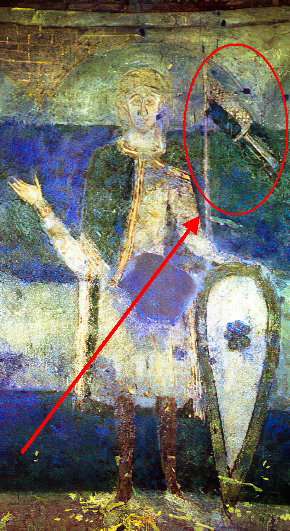
POGKPP#0001
Not a map, but flag/banner of Samo's Empire can be seen on a Znojmo fresco in Znojmo Rotunda made in 1134 by anonymous, which denies dumb theories that Danish flag was first national flag in that form. (Even fresco is older than danish flag).
Original
Attachments
Starboard 1 APP
08/08/2021 at 11:59 AM GMT+5:302 | # 💁┆legacy-mapping-help
Algol#0523
https://colab.research.google.com/drive/138l94-MF7bSPSrHhdSVwoOwoUnOj571x?usp=sharing
Original
Starboard 1 APP
08/07/2021 at 8:23 PM GMT+5:301 | # 🎥┆videos-and-video-discussion
POGKPP#0001
another flag
Original
Attachments
Starboard 1 APP
08/07/2021 at 7:56 PM GMT+5:301 | # 🎥┆videos-and-video-discussion

SuреrPоореr#2085
Was it this https://en.wikipedia.org/wiki/Provisional_Polish_Revolutionary_Committee?
Original
2 | # 🎥┆videos-and-video-discussion
POGKPP#0001
This "re-creation" is made according to the memories of veterans.
Original
Attachments

1 | # 🎥┆videos-and-video-discussion
POGKPP#0001
There was even Polish SSR around 1919/1922, but when Piłsudski defeated them, he ordered to burn all of flags, symbols and documents related to this communist republic
Original
Starboard 1 APP
08/07/2021 at 7:45 PM GMT+5:301 | # 🎥┆videos-and-video-discussion
RETF#9250
During the Egyptian revolution in 1919, three cities declared independence from the British empire, Zefta which established a Republic, Faraskor which establish a Kingdom and Menia which established an empire
Original
Starboard 1 APP
08/06/2021 at 11:57 PM GMT+5:30📌 1 | # 🗾┆real-mapping

1 | # 🗾┆real-mapping
Thames Mapping#3067
Here is my Cambodia research so far: 68: Funan founded 228: Thailand (later Lavo) taken 433: Champa lands OUT 450: Lavo Kingdom is independent 550: Chenla is Funan vassal 627: Chenla is independent 627: Funan to Chenla 707: Land Chenla is independent 707: Water Chenla is independent 802: Land Chenla to Khmer 802: Water Chenla to Khmer 881: Khmers expand North (view map) 889: Angkor IN 900: Lavo to Khmers 1000: Krong Battamang IN 1185: Luang Prabang to Khmer 1190: Champa states are Khmer vassals 1191: Champa states OUT 1191: Luang Prabang gains independence 1203: Champa to Khmers 1220: Champa is independent 1238: Sukhothai is independent 1434: Phnom Phenh IN
Original
Starboard 1 APP
08/02/2021 at 11:20 PM GMT+5:302 | # 🗾┆real-mapping
Ollie Bye#5175
https://i.stack.imgur.com/TDYXz.png
Original
Attachments
fabulous Dodolulupepe Ji 姬
how to map de facto and de jure borders well ^
Starboard 1 APP
08/01/2021 at 2:40 AM GMT+5:30📌 1 | # 🗾┆real-mapping
Starboard 1 APP
07/31/2021 at 7:41 PM GMT+5:30📌 1 | # 🌍┆general-chat

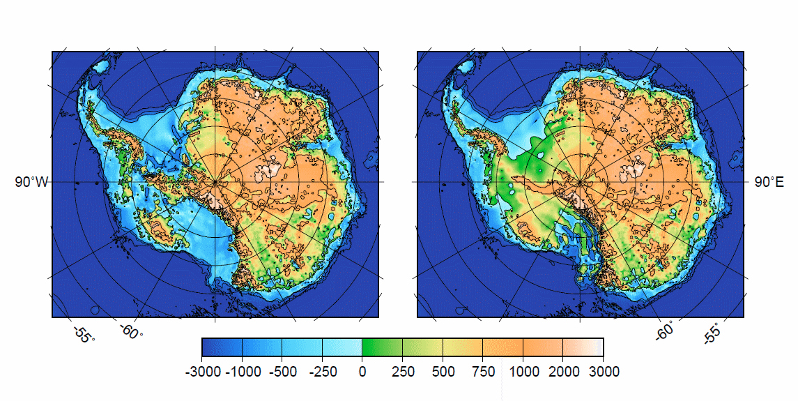
isnt it an archipelago underneath that ice? is it still frozen during this time?

if you removed all of the ice, the sea would flood Antarctica and it would become an archipelago of islands however, this is only the case because the Antarctic landmass has been depressed immensely because of the weight of the ice cap over the course of tens of thousands of years following deglaciation, it would "rebound", and turn back into a terrestrial continent, and look like the image on the left however, this isn't what Antarctica looked like in the past the ice has carved away much of the sediment and rocks on Antarctica's former surface, and its presence prevents new sediments and rocks from being deposited on the right is a reconstruction of what Antarctica might have looked like before the ice sheets formed
Starboard 1 APP
07/22/2021 at 8:55 PM GMT+5:301 | # 💁┆legacy-mapping-help
RETF#9250
https://ru.m.wikipedia.org/wiki/%D0%93%D0%BB%D0%B0%D0%B2%D0%B0_(%D1%81%D0%B5%D0%BB%D0%BE)
Original
1 | # 💁┆legacy-mapping-help
RETF#9250
Location of zagorie on here
Original
Attachments
Starboard 1 APP
07/21/2021 at 2:14 AM GMT+5:305 | # 💁┆legacy-mapping-help

Abraxicus#2482
visions: https://futureblind.com/2015/11/13/atlastory-mapping-the-history-of-the-world/ https://www.reddit.com/r/history/comments/6pf1cz/an_animated_googlemaps_of_world_history/ other posts throughout reddit, discord, and youtube general historical GIS websites of the world: https://chronmaps.com/world https://chronist.ru/ https://atlasofworldhistory.com http://www.historymapped.com https://www.openhistoricalmap.org/about https://www.runningreality.org/ http://geacron.com/home-en/ https://www.worldhistory.org/map/ https://historicborders.app/ • same thing https://historicborders.vercel.app/ • same thing https://www.reddit.com/r/MapPorn/comments/l5cr6z/interactive_map/ data https://github.com/aourednik/historical-basemaps data https://www.thenmap.net data http://dataforhistory.org data http://symogih.org/?lang=en data (1886-2019) https://icr.ethz.ch/data/cshapes/ (website wont load) https://mappimundi.com/explore historical GIS data for specific areas: britain (1832-1973) https://www.visionofbritain.org.uk/data/ europe https://hpolities.euratlas.net/ europe ww2 https://web.stanford.edu/group/spatialhistory/cgi-bin/site/pub.php?id=51 united states https://digital.newberry.org/ahcb/ united states http://parci.io united states https://www.nhgis.org spanish america https://dataverse.harvard.edu/dataverse/hgis-indias?q= japan https://dtl.macmillan.yale.edu/ china https://sites.fas.harvard.edu/~chgis/data/chgis/ rome https://dh.gu.se/dare/ rome https://orbis.stanford.edu rome/greece https://klokantech.github.io/roman-empire/#7.82/39.611/22.479/0/8 rome/greece/byzantine/celtic/ancient near eastern/early medieval https://pleiades.stoa.org/downloads franks http://www.menestrel.fr/?-Ressources-&lang=en#3451 germany/austria https://histogis.acdh.oeaw.ac.at/ • maps https://zenodo.org/record/2650712
Original
Starboard 1 APP
07/20/2021 at 5:44 PM GMT+5:30📌 1 | # 🗾┆real-mapping
some indian states missing too https://www.euratlas.net/history/hisatlas/india/index.html
Starboard 1 APP
07/20/2021 at 4:48 AM GMT+5:301 | # 🗾┆real-mapping
Ollie Bye#5175
@User Not Found If you want to show the population, write the known estimates in a spreadsheet. Put the 1547 A1, 1548 in A2, and so on, and then put the known estimates next to them (B1, B2, etc.). Then you can use this formula to calculate the population for individual years for which you don't have an estimate: Pₚ + (Pₛ - Pₑ) / (Dₛ - Dₑ) P = Population estimate D = Date ₚ = of the cell above ₛ = in row of the last estimate ₑ = in the row of the next estimate
Original
Starboard 1 APP
07/18/2021 at 4:02 AM GMT+5:302 | # 💁┆legacy-mapping-help

RN_Renato#5579
"According to the census in 1568, Teke Sanjak consisted of 5 districts in total, namely Antalya, Karahisar-ı Teke (Serik), Elmalı, Kalkanlı and Kaş. It consisted of a total of 5 accidents. Antalya accident; Kurdish, İğdir, Istanos and Muslu townships, Karahisar-ı Teke district; It consisted of Serik, Mükerrem Gömü and Bağovası sub-districts. According to the tahrir, Elmalı, Kalkanlı and Kaş are only recorded as accidents."
Original
Starboard 1 APP
07/18/2021 at 1:40 AM GMT+5:303 | # 🗾┆real-mapping
Dodolulupepe#2781
Byzantine is a cringe name, they called themselves Romans. the term was only invented in the 15th century
Original


Starboard 1 APP
07/16/2021 at 11:54 PM GMT+5:303 | # 🗾┆real-mapping
Ollie Bye#5175
Here's an example. On the left is typically how less experienced mappers draw lines - they go directly from the label to the thing they're labelling. On the right is a more organised set of lines that only go diagonally or orthogonally. It looks tidier and just better IMO.
Original
Attachments
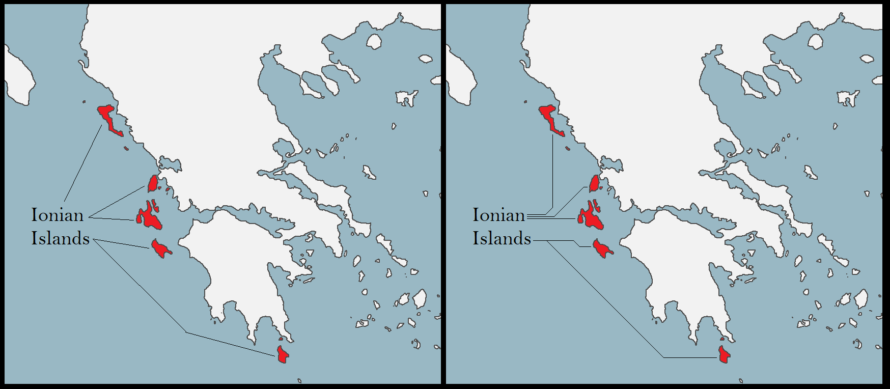
Starboard 1 APP
07/13/2021 at 10:59 PM GMT+5:303 | # 🗾┆real-mapping
Algol#0523
my "should you show the silesian duchies or not" chart
Original
Attachments
Starboard 1 APP
07/13/2021 at 5:05 AM GMT+5:30📌 1 | # 🌍┆general-chat
https://docs.google.com/spreadsheets/d/13O3IxKSM2VYzAhGA1y206_Pjk6_65syvXZ4O8UQHOew/edit#gid=114121551 Okay, I've downloaded the relevant spreadsheets and reformatted them in Google Sheets to be more user-friendly.

Chandler -1000 City,OtherName,Country,Latitude,Longitude,Certainty,-2250,-2000,-1800,-1600,-1360,-1200,-1000,-800,-712,-650,-430,-200,-100,100 Ebla,Syria,35.7984,36.79873,1,30,000 Nippur,Iraq,32.12694,45.23079,1,30,000 A Coruna,Coruna, A Coruña,Spain,43.36234,-8.41154,1 Aachen,Aix-la-Chapelle,Ge...
Jump to the message and read the rest of the conversation to understand the context. (That message was pinned by Abraxis BTW)
POGKPP
07/13/2021 at 4:58 AM GMT+5:30Great pdf document of my point for context (Describing only Cieszyn Silesia) http://otworzksiazke.pl/images/ksiazki/slask_cieszynski_w_okresie/slask_cieszynski_w_okresie.pdf
Davidmin
Jump to the message and read the rest of the conversation to understand the context. (That message was pinned by Abraxis BTW)
Starboard 1 APP
07/12/2021 at 6:53 PM GMT+5:30⭐ 1 | # 🗾┆real-mapping
The Dutch Coast is fucked and modern. Your Morocco is way too big (I think we all know who to blame for that) As already said, you're missing Italian citystates Prior to the Sunderbund War, Switzerland is more akin to the German Confederation than a unified country as the federal government was insanely weak. Regardless tho, it makes no sense to only show Neuchatel as separate just because they're in PU with the Dutch. In and Kniphausen should be shown as separate from Oldenburg In 1814, Vorpommern was ceded to Denmark in exchange for Norway and in 1815 it was ceded to Prussia. Regardless it should not be shown as Swedish. Schleswig and Saxe-Lauenberg should be shown as states in Personal Union with Denmark. The island to the northeast of Holstein belongs to Schleswig. You're missing the Banatian and Transylvanian Military frontiers. The Silesian Duchies are an odd choice as they are not really existing in terms of administration. It's likely showing the various titles of British Nobility as autonomous. Monaco is non-existent. Make sure to show the pre-1848 border. Nice appears to be French on this map, but my eyes might be playing tricks on me. Capraia belongs to Sardinia-Piedmont Coppenbrügge should be Dutch. Neutral Moresnet isn't shown. A lot of the German states are missing small exclaves, but that's an easy mistake and also a pain in the ass. A lot of the borders are anachronistic and have land trades from later on. Here's a map of Hanover as an example of what I mean (Sorry for the small size)
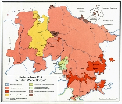
"The Silesian Duchies are an odd choice as they are not really existing in terms of administration. It's likely showing the various titles of British Nobility as autonomous. " what?


Starboard 1 APP
06/27/2021 at 3:17 AM GMT+5:30📌 1 | # 🗾┆real-mapping
labeled cities map for middle east & surroundings if anyone is interested Q&A: q- what projection a: pseudo mercator, pretty much works with mercator q- how to use, the background is all white! a- put it as a layer above the map and set to multiply q- how big is this a- width is 12k pixels q- my map is mercator/pseudo-mercator and it doesnt fit my map a- you have to manually resize it and adjust the location!, the convenient thing is youd only have to resize, not make a shattered glass diagram for it to work q- everything works well but the black text doesnt contrast well a- duplicate the layer to be under the original layer select all white areas with a high magic wand tolerence, delete, select every non-transparent pixel with a high tolerence and set to white, and expand the pixels, set the opacity q- i resized the map (most likely downsized it) and the text looks bad, what should i do? a- if you're using pdn, make the quality bubic or bilinear (better if bicubic when downsizing), not nearest neighbour, do that during or before the resizing procedure, not after finishing it or going back 1-2 steps, go back atleast 3 from the last step for it to be guaranteed to work q- i want it more bold! a- duplicate the layer to be above it and set opacity, usually 127 would work q- i want to make capitals and important cities a- you'd have to do that manually by removing some cities and their labels, but this maps saves you a lot of work for the other cities

Starboard 1 APP
06/26/2021 at 8:08 AM GMT+5:303 | # 🌍┆general-chat

zed381#3550
https://media.discordapp.net/attachments/625834378202972200/858167143547011092/unknown.png reminder that if you are doing world war 2 to show that ostland formed gradually
Original
Attachments
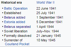
Starboard 1 APP
06/13/2021 at 1:22 AM GMT+5:301 | # 🗾┆real-mapping
kailanmapper#7003
https://drive.google.com/drive/folders/13E10_pQUXcsQ0Z6mjlI-vK7iQqdF_gkN
Original
Starboard 1 APP
06/05/2021 at 3:06 AM GMT+5:301 | # 🌍┆general-chat
Dsfisher#2949
On Mobil rn, I'll see if it's accurate with my source later
Original
Starboard 1 APP
06/03/2021 at 7:10 PM GMT+5:30📌 1 | # 🌍┆general-chat

Folia Histórica del Nordeste, Nº 18 (Resistencia, 2010) IIGHI, CONICET - IH, UNNE The Argentina–Paraguay Border. Stages of Delimitation. (1618-1950) By Ernesto J.A.Maeder
Starboard 1 APP
06/03/2021 at 12:06 PM GMT+5:301 | # 🌍┆general-chat
Dsfisher#2949
http://historia.anasnc.senatics.gov.py/index.php/expedicion-de-manuel-antonio-ramos-hacia-el-sur http://historia.anasnc.senatics.gov.py/index.php/expediente-sobre-los-fuertes-del-chaco-santa-elena-monteclaro-orange-y-formoso It seems Paraguay did establish forts in the Chaco, south of its current border, as an attempt to enforce its claim to the region But that effort was basically abandoned after 1842
Original
1 | # 🌍┆general-chat

Perseus#5086
ARGENTINA Y EL MUNDO LÍMITES Y FRONTERAS INTERNACIONALES Instituto Geográfico Nacional de la República Argentina https://static.ign.gob.ar/anida/fasciculos/fasc_limites_fronteras_internacionales.pdf
Original
Starboard 1 APP
06/02/2021 at 8:18 PM GMT+5:302 | # 💁┆legacy-mapping-help

Mazing ۞#0789
The conquest of In Salah was actually done in 1900-1901 yeah
Original
Attachments
Starboard 1 APP
06/02/2021 at 1:26 PM GMT+5:30📌 2 | # 🗾┆real-mapping
I recommend this channel for Indonesia https://www.youtube.com/channel/UCInxmQ2FBoKC6gL71adum1A
Starboard 1 APP
06/02/2021 at 4:25 AM GMT+5:30📌 1 | # 🗾┆real-mapping
https://homeyra.files.wordpress.com/2008/05/persia-territory-history.gif Some changes need making to the Ottoman-Iranian border.
Starboard 1 APP
06/02/2021 at 12:57 AM GMT+5:30📌 3 | # 🗾┆real-mapping

I present to you, the most underrated episode of World War I. Imam Yahya: "You were the Chosen One! It was said that you would destroy the entente, not join them!" Al Motawakil Alla Allah: "I hate you!" Imam Yahya: "You were my son, Motawakil. I loved you."
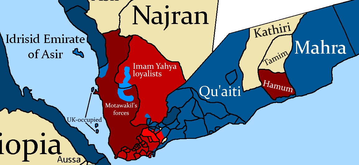
Starboard 1 APP
05/27/2021 at 10:22 PM GMT+5:30📌 2 | # 🗾┆real-mapping
Starboard 1 APP
05/27/2021 at 8:25 PM GMT+5:301 | # 🗾┆real-mapping

Vulpes#8645
Gregorian and Julian calendars
Original
📌 1 | # 🗾┆real-mapping

The important thing when it comes to the sources about the first months of the Russian Civil war until 1 February 1918 is that all of the dates of that period are the old style ones with no exceptions. There is a significant amount of dates from that period in Wikipedia that are the old style ones mixed with the new style to the point that it is very hard to say where it's the old style and where it's the new style. A great example is the Crimean People's Republic page. https://en.wikipedia.org/wiki/Crimean_People%27s_Republic

Starboard 1 APP
05/26/2021 at 12:45 AM GMT+5:301 | # 🗾┆real-mapping
A.S. Mapping#6819
Yeah you are right but I was just pointing it out.
Original
Starboard 1 APP
05/25/2021 at 4:14 AM GMT+5:301 | # 🗾┆real-mapping
Algol#0523
i've explained it multiple times before but here goes
Original
Starboard 1 APP
05/19/2021 at 8:49 PM GMT+5:301 | # 🗾┆real-mapping
Abraxis#2482
Original
Starboard 1 APP
05/17/2021 at 7:18 AM GMT+5:302 | # 🗾┆real-mapping
A.S. Mapping#6819
Also there was this trend in many states when a ruler would die, governors of castles and forts would usually become independent and they would have to be subdued or convinced to swear loyality.
Original
1 | # 🗾┆real-mapping
Dsfisher#2949
not every group even used territory as borders
Original
Starboard 1 APP
05/16/2021 at 2:13 AM GMT+5:302 | # 🗾┆real-mapping
Algol#0523
https://en.wikipedia.org/wiki/Fucine_Lake
Original
Starboard 1 APP
05/11/2021 at 7:21 PM GMT+5:302 | # 🗾┆real-mapping

Drex#1188
I don't get the point of leaving random gaps in high mountain areas, mostly because I wouldn't be able to pinpoint a time when they would stop being such
Original
Starboard 1 APP
05/09/2021 at 11:29 PM GMT+5:301 | # 🗾┆real-mapping
Abraxis#2482
> The problem I've always had with the Antichi Stati Italiani page is that it starts to get very arbitrary in what people have set up a Wikipedia page for vs what people haven't and what people have added on the list vs what people haven't. For example, it lists the Stato Pallavicino and Stato Landi and some sandbar on the Po that was supposedly an episcopal state due to a loophole in a treaty, but there are a ton of other territorial lordships within 15th-century Milan that aren't significantly different from e.g. the Pallavicino state but are not listed. It's particularly murky with Abbacies, there weren't any Imperial Abbeys in Italy at all but there were some Territorial Abbeys (both listed and unlisted) that present a challenge in how to represent them.
Original
Starboard 1 APP
05/09/2021 at 7:32 PM GMT+5:302 | # 🗾┆real-mapping

AbdurRahman AbdulMoneim#6548
@RETF@A.S. Mapping turns out the famous medieval ottoman flag (the three crescents and green oval one) actually has no proof of it being adopted
Original
Starboard 1 APP
05/09/2021 at 3:47 AM GMT+5:301 | # 🗾┆real-mapping
RETF#9250
Keep in mind that they controlled the "wahat" (the oasis), so applying the extremely thin coastline logic to here doesn't really work, Same for now it abruptly ends at the middle of upper Egypt, something that's worthy of mention is that the hawarra de jure controlled upper Egypt, so showing them as autonomous would be pretty nice
Original
Starboard 1 APP
05/09/2021 at 3:18 AM GMT+5:30📌 1 | # 🗾┆real-mapping
Starboard 1 APP
05/06/2021 at 6:26 PM GMT+5:301 | # 🎥┆videos-and-video-discussion
RETF#9250
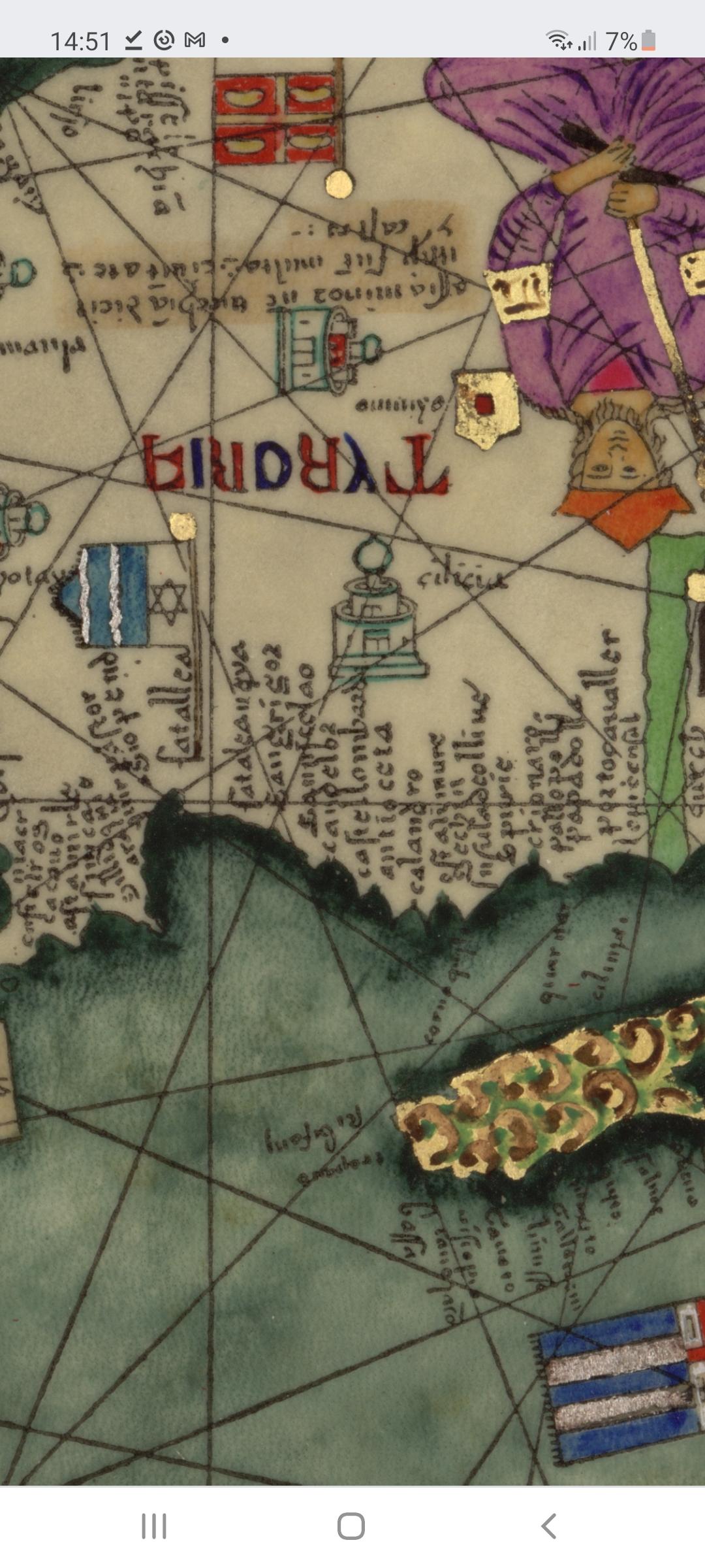
The more accurate reconstruction and the original source
Original
Attachments
1280px-Flag_of_the_Anatolian_Beylik_of_Teke.svg.png Screenshot_20210506-145115_Chrome.jpg
Starboard 1 APP
05/05/2021 at 10:32 PM GMT+5:301 | # 🗾┆real-mapping
Drex#1188
About the eagle flag, I recall it being described as such in Spanish medieval songs, but it was a war flag thou
Original
Starboard 1 APP
05/04/2021 at 12:42 AM GMT+5:301 | # 🗾┆real-mapping

Bapo#2473
Looks good, just fyi the PUs in Germany were considered "British dominions" by the British kings.
Original
Starboard 1 APP
05/04/2021 at 12:37 AM GMT+5:301 | # 🎥┆videos-and-video-discussion
Bapo#2473
also area between Netherlands and Flanders: https://www.cambridge.org/core/journals/netherlands-journal-of-geosciences/article/holocene-landscape-evolution-of-an-estuarine-wetland-in-relation-to-its-human-occupation-and-exploitation-waasland-scheldt-polders-northern-belgium/7AF55FC607851F36EF2937CAFEAE1775
Original
1 | # 🎥┆videos-and-video-discussion
Bapo#2473
here's a study about it: https://sci-hub.se/https://www.brepolsonline.net/doi/abs/10.1484/M.CORN.1.101554
Original
1 | # 🎥┆videos-and-video-discussion
Bapo#2473
There were already some long dunes in the current coastline, the Flemish built dykes between those dunes which caused the Flemish estuary to dry out naturally.
Original
Starboard 1 APP
05/03/2021 at 5:20 PM GMT+5:301 | # 🗾┆real-mapping

Brazilіan#1561
These territories formed a composite state under the House of Savoy until the promulgation of a single constitution, the Statuto Albertino, was established in 1848.
Original
1 | # 🗾┆real-mapping
Brazilіan#1561
show savoy's states as it is considered a "composite state" like aragon
Original
Starboard 1 APP
05/02/2021 at 8:01 PM GMT+5:301 | # 🗾┆real-mapping

POGKPP#9056
Another quote from Halych-Volhynia chronicle about quite large border change, and exchanging two bordering towns. "Potem zaś król [Andrzej II węgierski - przyp. wł.] poszedł na Lestka. Daniel zaś u Lestka był. Lestko posłał posła swojego Leszczyca Pakosława wojewodę by rzekł: "Nie jest dobrze bojarowi panować w Haliczu, pojmij więc córkę moją za syna swojego Kolomana i posadź go w Haliczu". Spodobała się królowi Andrzejowi rada Pakosławowa i spotkał się z Lestkiem na Spiszu i pojął córkę jego za syna swojego i posłał na Władysława do Halicza i uwięził [go] i w tym więzieniu [on] umarł. [...] Król posadził syna swojego w Haliczu, a Lestkowi dał Przemyśl, a Pakosławowi Lubaczów."
Original
1 | # 🗾┆real-mapping
POGKPP#9056
Most of borders on the East changed after Leszek I Biały expansion, and later when he lost these lands almost entirely changed (Because all of Polish borders were very accurately described). Also in some places like in the south, rivers has changed. And there are detailed descriptions of border changes, like this from Halych-Volhynia Chronicle. Here is a quote _"Po zwycięstwie Mścisławowym i po litewskim wojowaniu Lachów zawarł pokój Lestko z Danielem i Wasylkiem [...] Odstąpił [wówczas] Lestko od Aleksandra [Wsiewołodowicza]."_ It means that Leszek resigned from lands between river Wieprz and Bug, and that caused border to change for about few pixels for a Rus'. There were also a looooot more of detailed descriptions of changing borders, but I don't really remember all of quotes from every chroncile... Also my historian friend helped me in putting each pixel in the right place, so many of these changes were also only possible because of him.
Original
2 | # 🗾┆real-mapping
Drex#1188
Regarding Iberia on the map: The constituent kingdoms of Aragon must be shown, as they had their own institutions and laws, mostly under the figure of the "generality". I've seen authors define Aragon as either a composite monarchy, a quasi-confederacy, or a personal union of kingdoms. In any case, the internal autonomy of Aragonese entities was way higher than that of Castille's. Regarding Castille, the provinces and kingdoms were simple subdivisions, some had retained privileges or some own laws, but that would make it more of an equivalent to a French province than an internal autonomy. The only places I'd advise showing would be the three Basque Lordships, which had a separate fiscal policy and an extended law code under the "fuero". Seeing as the rest of the map does not show subdivisions like English counties or French provinces like the Dauphiné, I'd just keep it this way, not showing Castille's internals. Portugal had a similar model to Castille, it had internal kingdoms and that, but they were more of a de-iure entity.
Original
Starboard 1 APP
05/01/2021 at 10:24 PM GMT+5:301 | # 🌍┆general-chat

TeeMee123#9969
https://phys.org/news/2011-01-mathematical-complex-societies-emerge-collapse.html ( https://escholarship.org/uc/item/5536t55r )
Original
Starboard 1 APP
04/29/2021 at 12:05 AM GMT+5:302 | # 🗾┆real-mapping
POGKPP#9056
Henry IV Probus, duke of Wrocław, and Senior of entire Poland was part of the Holy Roman Empire since 1280 to his death. Quote from Vienna 1280 congress: Aby za naszych czasów między nami, mianowicie W. [Władysławem - przyp. wł.], z Bożej łaski księciem opolskim, a najukochańszym naszym zięciem, znakomitym księciem H. [Henrykiem - przyp. wł.] z tejże [Bożej] łaski księciem śląskim [i] panem Wrocławia, trwała w pełni należyta miłość, jednomyślność i stałość wieczystego pokoju, porzuciwszy wszelkie nieporozumienia i urazy, wyrażamy zgodę naszą na zabiegi naszego kochanego zięcia w kierunku osiągnięcia królestwa i korony w Polsce, w tej sprawie pragniemy zawsze służyć naszemu zięciowi naszą radą, pomocą i życzliwością z tym jednakże, iż jeżeli uzyska, jak się tego spodziewamy, wspomniane królestwo i koronę, córkę naszą najdroższą a swoją małżonkę, wraz ze sobą ukoronuje. Other document: http://wratislavia.archeo.uni.wroc.pl/8-tom/2.pdf
Original
Starboard 1 APP
04/26/2021 at 8:58 PM GMT+5:301 | # 🗾┆real-mapping
POGKPP#9056
England was an exception.
Original
1 | # 🗾┆real-mapping
POGKPP#9056
Also, I don't know how it worked in muslim world. But in feudal Europe there was a rule saying "vassals of my vassal are not my vassal".
Original
Starboard 1 APP
04/26/2021 at 4:16 AM GMT+5:30📌 1 | # 🗾┆real-mapping
@fabulous Dodolulupepe Ji 姬 Here's a way to visualise what I was saying earlier, on a fictional island. In this scenario: -Minor states only kept records of their own history, so if they disappear then the records disappear. The history of the major states is recorded properly, however. -Around the year 2000, state N conquers the whole island, and makes detailed records of all the states that existed at the time. It also divides the island into clearly-defined provinces and princely states. So with my method, the minor states are missing, but the presentation is consistent for the whole duration of the island's history. It acknowledges that our understanding of the small states is limited, and that many of them cannot be mapped, thus not mapping any of them. Your method includes some extra detail, but the treatment of the small states is inconsistent. For example, in the year 500 we have two neighbouring states, B and G. You map state G because it still existed 1500 years later when state N recorded it. But as state B was conquered during the rise of state D around 1000, you would not map it. Which states you map, ends up just being based on which states happened to survive to the present day, and doesn't really reflect what's going on at the time. It also implies the amount of small states increased over time, which as you can see, they didn't.
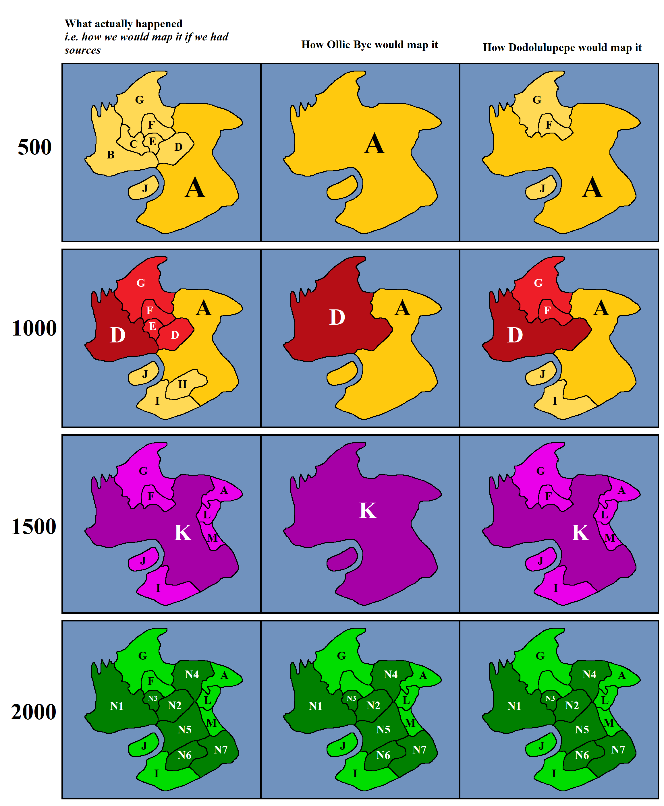
Starboard 1 APP
04/26/2021 at 2:55 AM GMT+5:301 | # 🗾┆real-mapping
A.S. Mapping#6819
This is why we should rely on one primary source and other secondary sources since we kinda have to make our own analysis. This is why many mappers hesistate to answer general questions like: "How do you research". It just is not that simple.
Original
1 | # 🗾┆real-mapping
Ollie Bye#5175
Going back to India, you can get into a similar situation with small states. As I touched on earlier, there have always been unaccountably large numbers of small states there. Every town had autonomy to a certain extent. Unfortunately the body of sources is not sufficient to map these. However, when the British arrived they brought a more scientific approach towards history to India. The history of the small states that happened to exist at the time was documented. So we have this snapshot in time of this constantly evolving web of small states. What we need to remember, is that it is just that - a snapshot. You cannot reconstruct the history of the small states just by going through the ones recorded by the British, as the ones that disappeared before the British arrived aren't recorded. If you attempt to map them, you will end up showing virtually none of them before 1000, and gradually more as time passes. This gives a false impression to the viewer in a similar way to how I described earlier with the Ottoman border in Egypt, even though, once again, it's not outright wrong. So to keep the 1600s/1700s consistent with the rest of the video, I had no option but to not show them.
Original
Starboard 1 APP
04/25/2021 at 11:00 PM GMT+5:301 | # 💁┆legacy-mapping-help
Dodolulupepe#2781
and @User Not Found here is the paint.net download for gigamap https://drive.google.com/drive/folders/18SKqPS3qZCMeBdJNe2d498doeVQU56Tx
Original
1 | # 💁┆legacy-mapping-help
Dodolulupepe#2781
use gigamap https://drive.google.com/drive/folders/1d9zIoshDUIBzgbp0fr0cHlGV_c_pb-7c it has lots of layers
Original
Starboard 1 APP
04/19/2021 at 9:45 PM GMT+5:301 | # 🗾┆real-mapping
A.S. Mapping#6819
again its not my research but some people here might need it
Original
Attachments

Starboard 1 APP
04/18/2021 at 3:58 AM GMT+5:302 | # 🗾┆real-mapping
A.S. Mapping#6819
History of The first Saudi state Part 1: under emir Muhammad ibn Saud 1744 ibn AbulWahhab arrives and is given bay'aa by ibn Saud, and the first saudi state is established. although ibn saud has been sheikh/emir of diriyah for 20 years before that, and the sheikhdom itself existed for 3 centuries before that, this is the date where the saudi state was really established. 1745 uaynah gives bay'aa and is added 1746 manfuha and huraymla give bay'aa are added, war with riadh 1747 war with riadh 1748 war with riadh and tharmada 1749 war with riadh 1750 darma gives bay'aa is added, war with riadh and tharmada 1751 darma defects, war with riadh 1752 invasion/war with al-kharj (same area as khadarim), huraymla defects 1753 manfuha defects 1754 riadh asks for truce 1755 darma is conquered by force 1756 quway' gives bay'aa and is added, war with manfuha 1757 Al-huwta gives is added, invasion of/war with manfuha, riadh and jalajil (almujama'ah) 1758 war with tharmada 1759 thadiq and al-qusayb are added, the emir of haasa invades huraymla and al-jubaila (right east to uyanah) 1760 invasion/war with al-kharj, and al washm in shaqra 1761 war /invasion of sudair and riadh and manfuha 1762 war with manfuha and riadh, addition of al-shaqra gives bay'aa to ibn saud and becomes a part of his state 1763 war between riadh and diriyah, war with ahsa and a districts near the city of Gerra/Hassa/Hofuf is captured, the emir of riadh gives bay'aa to ibn saud 1764 war with some of dhufair tribe, war with the yemenese emirate of najran which is allied with the ajman tribe (current UAE?), najran's army reach al-ha'ir south of riadh, and a battle occurs there 1765 ibn saud dies, war with riadh again My friend did this research and shared it with me.
Original
Starboard 1 APP
04/18/2021 at 1:14 AM GMT+5:301 | # 🎥┆videos-and-video-discussion
A.S. Mapping#6819
Starboard 1 APP
04/09/2021 at 7:32 PM GMT+5:30📌 2 | # 😂┆off-topic
https://en.wikipedia.org/wiki/List_of_calendars I wonder if this would make a good video.

From what I studied; the Islamic Calendar was introduced by Caliph Umar who ruled from 634-644 so the date of establishment is wrong.

Starboard 1 APP
04/04/2021 at 9:09 PM GMT+5:30⭐ 7 | # 🗾┆real-mapping

rasht 682 qazvin 1067 anizzah 1101 al maklah 1271 al qunfudha 1311 diriyah 1446 al houdaida 1455 uyaynah 1472 al samawa 1494 umm al rashrash 1500 mahabad 1500 buraida 1577 khobar/al dammam 1600 al shaqra' 1600 zamwa/sulaymaniyah 1650 doha/al bidda' 1681 al quway' 1700 al-ru'ays 1700 al diwaniyah 1747 al shatra 1787 al manama/al-muharraq 1796 baji 1800 haditha 1800 abadan 1827 dubai 1833 al shomly 1850 al ramadi 1869 el qamishili 1921 dates with 1 or two zeros at the right are assumed/estimated This research is not mine
Starboard 1 APP
04/04/2021 at 6:25 AM GMT+5:303 | # 🗾┆real-mapping

EmperorTigerstar#5652
@Ollie Bye the website that showed Native American land acquisitions for the US had areas that had no treaty along the coasts. Considering these areas overlapped with early Spanish settlements I took that to mean that such coastal areas was the true extent of de facto Spanish control at the time
Original
Starboard 1 APP
04/03/2021 at 8:10 AM GMT+5:304 | # 🌍┆general-chat
Algol#0523
there's a lightweight software called climasim you can use to do rough simulations of the climate using your own configurations
Original